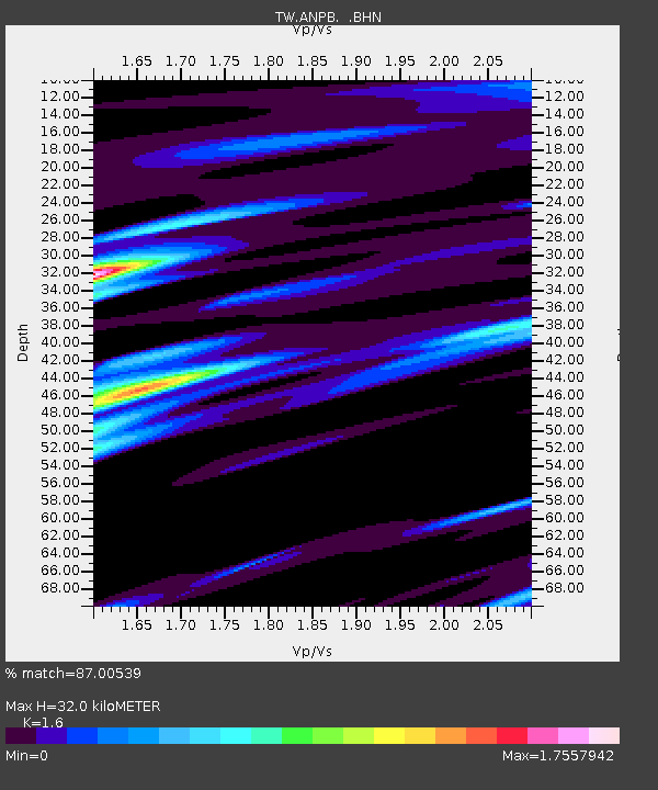
ANPB AN-PU - Earthquake Result Viewer

Earthquake location: New Guinea, Papua New Guinea
Earthquake latitude/longitude: -6.8/143.8
Earthquake time(UTC): 2000/03/03 (063) 22:22:40 GMT
Earthquake Depth: 10 km
Earthquake Magnitude: 6.3 MB, 6.7 MS, 6.6 MW, 6.5 MW
Earthquake Catalog/Contributor: WHDF/NEIC
Network: TW Broadband Array in Taiwan for Seismology
Station: ANPB AN-PU
Lat/Lon: 25.19 N/121.52 E
Elevation: 825 m
Distance: 38.5 deg
Az: 326.5 deg
Baz: 142.776 deg
Ray Param: 0.07552492
Estimated Moho Depth: 32.0 km
Estimated Crust Vp/Vs: 1.60
Assumed Crust Vp: 6.289 km/s
Estimated Crust Vs: 3.93 km/s
Estimated Crust Poisson's Ratio: 0.18
Radial Match: 87.00539 %
Radial Bump: 400
Transverse Match: 78.68348 %
Transverse Bump: 400
SOD ConfigId: 3744
Insert Time: 2010-03-09 21:27:47.247 +0000
GWidth: 2.5
Max Bumps: 400
Tol: 0.001

Signal To Noise

ChannelStoNSTALTA
TW:ANPB: :BHN:20000303T22:29:32.22999Z1.74646012.5375614E-61.4529742E-6
TW:ANPB: :BHE:20000303T22:29:32.22999Z0.780866441.1401663E-61.4601297E-6
TW:ANPB: :BHZ:20000303T22:29:32.22999Z2.69453072.7622427E-61.0251294E-6
Arrivals
Ps3.3 SECOND
PpPs12 SECOND
PsPs/PpSs16 SECOND