You are here: Home > Network List > TW - Broadband Array in Taiwan for Seismology Stations List
> Station ANPB AN-PU > Earthquake Result Viewer
ANPB AN-PU - Earthquake Result Viewer
| Earthquake location: |
Java, Indonesia |
| Earthquake latitude/longitude: |
-7.9/110.2 |
| Earthquake time(UTC): |
2001/05/25 (145) 05:06:10 GMT |
| Earthquake Depth: |
143 km |
| Earthquake Magnitude: |
5.8 MB, 6.3 MW, 6.3 MW |
| Earthquake Catalog/Contributor: |
WHDF/NEIC |
|
| Network: |
TW Broadband Array in Taiwan for Seismology |
| Station: |
ANPB AN-PU |
| Lat/Lon: |
25.19 N/121.52 E |
| Elevation: |
825 m |
|
| Distance: |
34.7 deg |
| Az: |
18.256 deg |
| Baz: |
200.032 deg |
| Ray Param: |
0.07714316 |
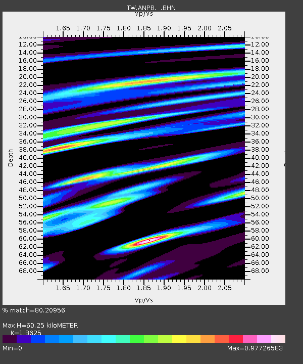
| Estimated Moho Depth: |
60.25 km |
| Estimated Crust Vp/Vs: |
1.86 |
| Assumed Crust Vp: |
6.289 km/s |
| Estimated Crust Vs: |
3.376 km/s |
| Estimated Crust Poisson's Ratio: |
0.30 |
|
| Radial Match: |
80.20956 % |
| Radial Bump: |
400 |
| Transverse Match: |
71.78025 % |
| Transverse Bump: |
400 |
| SOD ConfigId: |
4714 |
| Insert Time: |
2010-03-09 21:28:03.958 +0000 |
| GWidth: |
2.5 |
| Max Bumps: |
400 |
| Tol: |
0.001 |
|

Signal To Noise
| Channel | StoN | STA | LTA |
| TW:ANPB: :BHN:20010525T05:12:16.160011Z | 2.0372367 | 1.5042631E-6 | 7.383841E-7 |
| TW:ANPB: :BHE:20010525T05:12:16.160011Z | 1.0472304 | 6.7245776E-7 | 6.4212975E-7 |
| TW:ANPB: :BHZ:20010525T05:12:16.160011Z | 2.911166 | 1.8885798E-6 | 6.487366E-7 |
| Arrivals |
| Ps | 8.9 SECOND |
| PpPs | 26 SECOND |
| PsPs/PpSs | 34 SECOND |


