You are here: Home > Network List > TW - Broadband Array in Taiwan for Seismology Stations List
> Station ANPB AN-PU > Earthquake Result Viewer
ANPB AN-PU - Earthquake Result Viewer
| Earthquake location: |
Kermadec Islands, New Zealand |
| Earthquake latitude/longitude: |
-29.7/-178.6 |
| Earthquake time(UTC): |
2001/06/03 (154) 02:41:57 GMT |
| Earthquake Depth: |
178 km |
| Earthquake Magnitude: |
6.8 MB, 7.2 MW, 7.1 MW |
| Earthquake Catalog/Contributor: |
WHDF/NEIC |
|
| Network: |
TW Broadband Array in Taiwan for Seismology |
| Station: |
ANPB AN-PU |
| Lat/Lon: |
25.19 N/121.52 E |
| Elevation: |
825 m |
|
| Distance: |
79.2 deg |
| Az: |
307.099 deg |
| Baz: |
129.987 deg |
| Ray Param: |
0.04869515 |
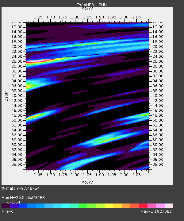
| Estimated Moho Depth: |
25.5 km |
| Estimated Crust Vp/Vs: |
1.64 |
| Assumed Crust Vp: |
6.289 km/s |
| Estimated Crust Vs: |
3.834 km/s |
| Estimated Crust Poisson's Ratio: |
0.20 |
|
| Radial Match: |
97.46754 % |
| Radial Bump: |
400 |
| Transverse Match: |
92.76695 % |
| Transverse Bump: |
400 |
| SOD ConfigId: |
4714 |
| Insert Time: |
2010-03-09 21:28:05.261 +0000 |
| GWidth: |
2.5 |
| Max Bumps: |
400 |
| Tol: |
0.001 |
|

Signal To Noise
| Channel | StoN | STA | LTA |
| TW:ANPB: :BHN:20010603T02:53:11.160Z | 4.0631223 | 2.890219E-6 | 7.113296E-7 |
| TW:ANPB: :BHE:20010603T02:53:11.160Z | 2.7776725 | 1.8044894E-6 | 6.4964075E-7 |
| TW:ANPB: :BHZ:20010603T02:53:11.160Z | 26.443056 | 9.0980275E-6 | 3.4406114E-7 |
| Arrivals |
| Ps | 2.7 SECOND |
| PpPs | 10 SECOND |
| PsPs/PpSs | 13 SECOND |


