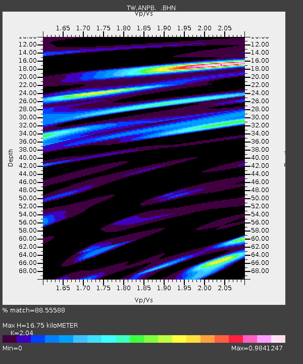
ANPB AN-PU - Earthquake Result Viewer

Earthquake location: Near East Coast Of Kamchatka
Earthquake latitude/longitude: 56.3/163.8
Earthquake time(UTC): 2001/08/02 (214) 23:41:06 GMT
Earthquake Depth: 14 km
Earthquake Magnitude: 5.9 MB, 6.2 MS, 6.3 MW, 6.2 ME
Earthquake Catalog/Contributor: WHDF/NEIC
Network: TW Broadband Array in Taiwan for Seismology
Station: ANPB AN-PU
Lat/Lon: 25.19 N/121.52 E
Elevation: 825 m
Distance: 43.5 deg
Az: 242.282 deg
Baz: 33.039 deg
Ray Param: 0.072499156
Estimated Moho Depth: 16.75 km
Estimated Crust Vp/Vs: 2.04
Assumed Crust Vp: 6.289 km/s
Estimated Crust Vs: 3.083 km/s
Estimated Crust Poisson's Ratio: 0.34
Radial Match: 88.55588 %
Radial Bump: 400
Transverse Match: 75.3196 %
Transverse Bump: 400
SOD ConfigId: 3753
Insert Time: 2010-03-09 21:28:12.182 +0000
GWidth: 2.5
Max Bumps: 400
Tol: 0.001

Signal To Noise

ChannelStoNSTALTA
TW:ANPB: :BHN:20010802T23:48:38.15999Z3.13110731.36134E-64.3477908E-7
TW:ANPB: :BHE:20010802T23:48:38.15999Z1.65622146.241358E-73.7684322E-7
TW:ANPB: :BHZ:20010802T23:48:38.15999Z8.3122422.3496868E-62.8267792E-7
Arrivals
Ps2.9 SECOND
PpPs7.7 SECOND
PsPs/PpSs11 SECOND