You are here: Home > Network List > AV - Alaska Volcano Observatory Stations List
> Station SPCR Ckakachatna River, Mount Spurr, Alaska > Earthquake Result Viewer
SPCR Ckakachatna River, Mount Spurr, Alaska - Earthquake Result Viewer
| Earthquake location: |
Southeastern Afghanistan |
| Earthquake latitude/longitude: |
33.1/69.5 |
| Earthquake time(UTC): |
2022/06/21 (172) 20:54:36 GMT |
| Earthquake Depth: |
10 km |
| Earthquake Magnitude: |
5.9 mwb |
| Earthquake Catalog/Contributor: |
NEIC PDE/us |
|
| Network: |
AV Alaska Volcano Observatory |
| Station: |
SPCR Ckakachatna River, Mount Spurr, Alaska |
| Lat/Lon: |
61.20 N/152.21 W |
| Elevation: |
984 m |
|
| Distance: |
80.1 deg |
| Az: |
19.096 deg |
| Baz: |
325.449 deg |
| Ray Param: |
0.048519645 |
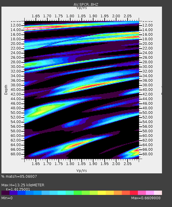
| Estimated Moho Depth: |
13.25 km |
| Estimated Crust Vp/Vs: |
1.61 |
| Assumed Crust Vp: |
6.566 km/s |
| Estimated Crust Vs: |
4.072 km/s |
| Estimated Crust Poisson's Ratio: |
0.19 |
|
| Radial Match: |
85.06807 % |
| Radial Bump: |
400 |
| Transverse Match: |
89.046005 % |
| Transverse Bump: |
400 |
| SOD ConfigId: |
28208852 |
| Insert Time: |
2022-07-05 21:04:03.497 +0000 |
| GWidth: |
2.5 |
| Max Bumps: |
400 |
| Tol: |
0.001 |
|

Signal To Noise
| Channel | StoN | STA | LTA |
| AV:SPCR: :BHZ:20220621T21:06:14.658986Z | 22.8733 | 1.1652253E-6 | 5.0942592E-8 |
| AV:SPCR: :BHN:20220621T21:06:14.658986Z | 4.621965 | 2.9803292E-7 | 6.448186E-8 |
| AV:SPCR: :BHE:20220621T21:06:14.658986Z | 2.399114 | 1.5323431E-7 | 6.387121E-8 |
| Arrivals |
| Ps | 1.3 SECOND |
| PpPs | 5.1 SECOND |
| PsPs/PpSs | 6.4 SECOND |


