You are here: Home > Network List > NM - Cooperative New Madrid Seismic Network Stations List
> Station SIUC Carbondale, IL > Earthquake Result Viewer
SIUC Carbondale, IL - Earthquake Result Viewer
| Earthquake location: |
Andreanof Islands, Aleutian Is. |
| Earthquake latitude/longitude: |
51.4/-178.1 |
| Earthquake time(UTC): |
2018/08/15 (227) 21:56:54 GMT |
| Earthquake Depth: |
20 km |
| Earthquake Magnitude: |
6.6 Mww |
| Earthquake Catalog/Contributor: |
NEIC PDE/us |
|
| Network: |
NM Cooperative New Madrid Seismic Network |
| Station: |
SIUC Carbondale, IL |
| Lat/Lon: |
37.71 N/89.22 W |
| Elevation: |
120 m |
|
| Distance: |
61.0 deg |
| Az: |
65.058 deg |
| Baz: |
314.3 deg |
| Ray Param: |
0.061152145 |
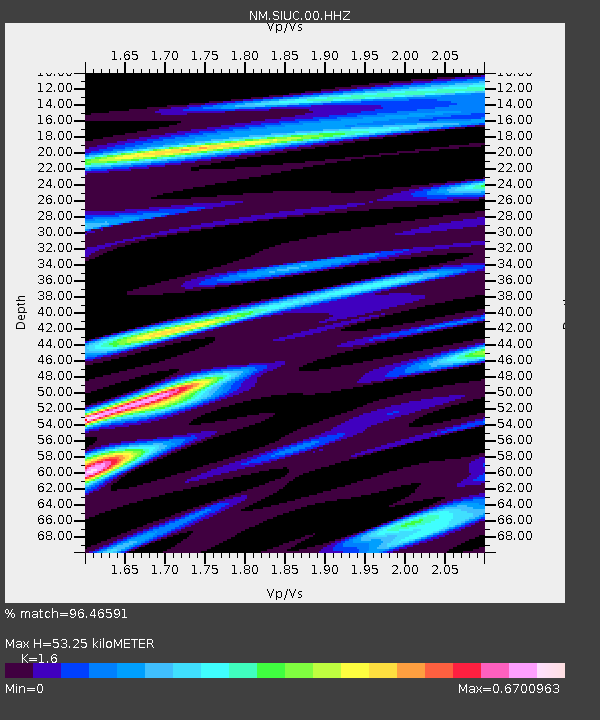
| Estimated Moho Depth: |
53.25 km |
| Estimated Crust Vp/Vs: |
1.60 |
| Assumed Crust Vp: |
6.444 km/s |
| Estimated Crust Vs: |
4.027 km/s |
| Estimated Crust Poisson's Ratio: |
0.18 |
|
| Radial Match: |
96.46591 % |
| Radial Bump: |
400 |
| Transverse Match: |
88.69622 % |
| Transverse Bump: |
400 |
| SOD ConfigId: |
2825771 |
| Insert Time: |
2018-08-29 22:09:06.854 +0000 |
| GWidth: |
2.5 |
| Max Bumps: |
400 |
| Tol: |
0.001 |
|

Signal To Noise
| Channel | StoN | STA | LTA |
| NM:SIUC:00:HHZ:20180815T22:06:35.519014Z | 59.543144 | 3.4172924E-6 | 5.7391873E-8 |
| NM:SIUC:00:HHN:20180815T22:06:35.519014Z | 13.652802 | 1.2690247E-6 | 9.294976E-8 |
| NM:SIUC:00:HHE:20180815T22:06:35.519014Z | 11.388653 | 1.4681402E-6 | 1.2891255E-7 |
| Arrivals |
| Ps | 5.2 SECOND |
| PpPs | 20 SECOND |
| PsPs/PpSs | 26 SECOND |


