You are here: Home > Network List > AV - Alaska Volcano Observatory Stations List
> Station SPCR Ckakachatna River, Mount Spurr, Alaska > Earthquake Result Viewer
SPCR Ckakachatna River, Mount Spurr, Alaska - Earthquake Result Viewer
| Earthquake location: |
Southern East Pacific Rise |
| Earthquake latitude/longitude: |
-21.4/-110.2 |
| Earthquake time(UTC): |
2022/06/24 (175) 00:00:18 GMT |
| Earthquake Depth: |
10 km |
| Earthquake Magnitude: |
5.8 mww |
| Earthquake Catalog/Contributor: |
NEIC PDE/us |
|
| Network: |
AV Alaska Volcano Observatory |
| Station: |
SPCR Ckakachatna River, Mount Spurr, Alaska |
| Lat/Lon: |
61.20 N/152.21 W |
| Elevation: |
984 m |
|
| Distance: |
88.9 deg |
| Az: |
341.083 deg |
| Baz: |
141.385 deg |
| Ray Param: |
0.04222041 |
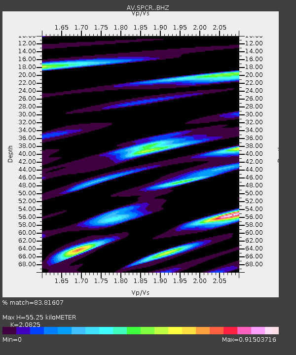
| Estimated Moho Depth: |
55.25 km |
| Estimated Crust Vp/Vs: |
2.08 |
| Assumed Crust Vp: |
6.566 km/s |
| Estimated Crust Vs: |
3.153 km/s |
| Estimated Crust Poisson's Ratio: |
0.35 |
|
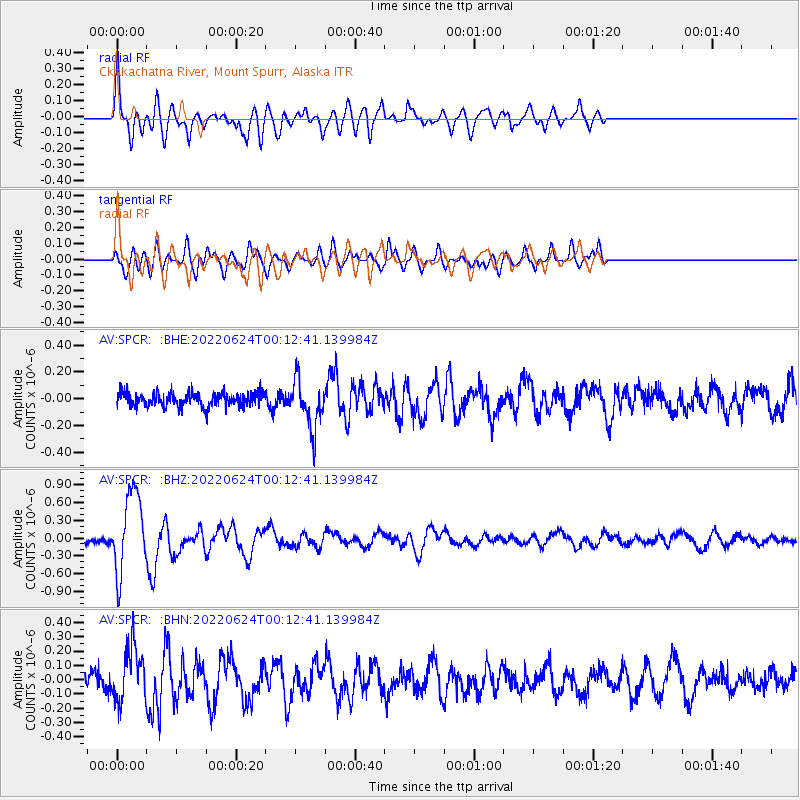
| Radial Match: |
83.81607 % |
| Radial Bump: |
400 |
| Transverse Match: |
70.161514 % |
| Transverse Bump: |
400 |
| SOD ConfigId: |
28208852 |
| Insert Time: |
2022-07-08 00:09:42.084 +0000 |
| GWidth: |
2.5 |
| Max Bumps: |
400 |
| Tol: |
0.001 |
|
Signal To Noise
| Channel | StoN | STA | LTA |
| AV:SPCR: :BHZ:20220624T00:12:41.139984Z | 14.087432 | 6.732859E-7 | 4.7793375E-8 |
| AV:SPCR: :BHN:20220624T00:12:41.139984Z | 3.4071312 | 1.8980485E-7 | 5.5708114E-8 |
| AV:SPCR: :BHE:20220624T00:12:41.139984Z | 3.5679755 | 1.8069181E-7 | 5.0642672E-8 |
| Arrivals |
| Ps | 9.3 SECOND |
| PpPs | 25 SECOND |
| PsPs/PpSs | 35 SECOND |


