You are here: Home > Network List > IW - Intermountain West Stations List
> Station MOOW Moose Ponds, Wyoming, USA > Earthquake Result Viewer
MOOW Moose Ponds, Wyoming, USA - Earthquake Result Viewer
*The percent match for this event was below the threshold and hence no stack was calculated.
| Earthquake location: |
Southern East Pacific Rise |
| Earthquake latitude/longitude: |
-21.4/-110.2 |
| Earthquake time(UTC): |
2022/06/24 (175) 00:00:18 GMT |
| Earthquake Depth: |
10 km |
| Earthquake Magnitude: |
5.8 mww |
| Earthquake Catalog/Contributor: |
NEIC PDE/us |
|
| Network: |
IW Intermountain West |
| Station: |
MOOW Moose Ponds, Wyoming, USA |
| Lat/Lon: |
43.75 N/110.74 W |
| Elevation: |
2128 m |
|
| Distance: |
64.8 deg |
| Az: |
359.555 deg |
| Baz: |
179.427 deg |
| Ray Param: |
$rayparam |
*The percent match for this event was below the threshold and hence was not used in the summary stack. |
|
| Radial Match: |
35.520832 % |
| Radial Bump: |
400 |
| Transverse Match: |
70.87317 % |
| Transverse Bump: |
400 |
| SOD ConfigId: |
28208852 |
| Insert Time: |
2022-07-08 00:21:50.676 +0000 |
| GWidth: |
2.5 |
| Max Bumps: |
400 |
| Tol: |
0.001 |
|
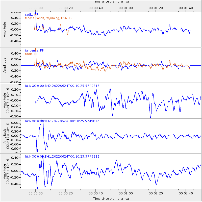
Signal To Noise
| Channel | StoN | STA | LTA |
| IW:MOOW:00:BHZ:20220624T00:10:25.574981Z | 11.560307 | 7.395579E-7 | 6.39739E-8 |
| IW:MOOW:00:BH1:20220624T00:10:25.574981Z | 2.5797372 | 2.96194E-7 | 1.1481557E-7 |
| IW:MOOW:00:BH2:20220624T00:10:25.574981Z | 2.148057 | 1.0521094E-7 | 4.8979583E-8 |
| Arrivals |
| Ps | |
| PpPs | |
| PsPs/PpSs | |


