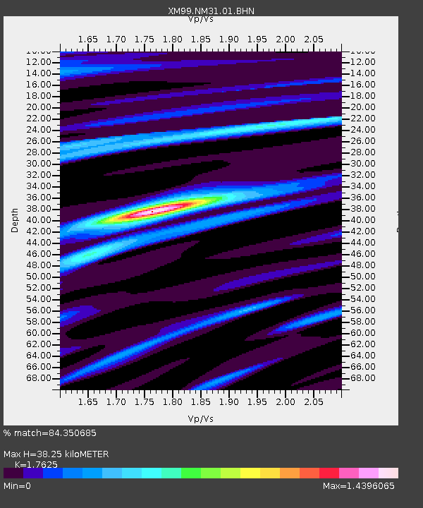
NM31 NewMexico31 - Earthquake Result Viewer

Earthquake location: South Of Panama
Earthquake latitude/longitude: 6.0/-82.7
Earthquake time(UTC): 2000/12/12 (347) 05:26:45 GMT
Earthquake Depth: 10 km
Earthquake Magnitude: 5.8 MB, 5.7 MS, 6.3 ME, 6.1 MW
Earthquake Catalog/Contributor: WHDF/NEIC
Network: XM Rio Grande Seismic Transect
Station: NM31 NewMexico31
Lat/Lon: 34.85 N/107.10 W
Elevation: 1676 m
Distance: 36.5 deg
Az: 325.122 deg
Baz: 136.252 deg
Ray Param: 0.07665589
Estimated Moho Depth: 38.25 km
Estimated Crust Vp/Vs: 1.76
Assumed Crust Vp: 6.502 km/s
Estimated Crust Vs: 3.689 km/s
Estimated Crust Poisson's Ratio: 0.26
Radial Match: 84.350685 %
Radial Bump: 314
Transverse Match: 60.96264 %
Transverse Bump: 400
SOD ConfigId: 27569
Insert Time: 2010-02-26 17:30:49.133 +0000
GWidth: 2.5
Max Bumps: 400
Tol: 0.001

Signal To Noise

ChannelStoNSTALTA
XM:NM31:01:BHN:20001212T05:33:20.333005Z1.13365131.1731853E-71.03487324E-7
XM:NM31:01:BHE:20001212T05:33:20.333005Z1.06913292.2370321E-72.0923798E-7
XM:NM31:01:BHZ:20001212T05:33:20.333005Z1.37905382.878717E-72.087458E-7
Arrivals
Ps4.8 SECOND
PpPs15 SECOND
PsPs/PpSs20 SECOND