You are here: Home > Network List > N4 - Central and EAstern US Network Stations List
> Station M50A Fremont, OH, USA > Earthquake Result Viewer
M50A Fremont, OH, USA - Earthquake Result Viewer
| Earthquake location: |
Southern East Pacific Rise |
| Earthquake latitude/longitude: |
-21.4/-110.2 |
| Earthquake time(UTC): |
2022/06/24 (175) 00:00:18 GMT |
| Earthquake Depth: |
10 km |
| Earthquake Magnitude: |
5.8 mww |
| Earthquake Catalog/Contributor: |
NEIC PDE/us |
|
| Network: |
N4 Central and EAstern US Network |
| Station: |
M50A Fremont, OH, USA |
| Lat/Lon: |
41.40 N/83.04 W |
| Elevation: |
176 m |
|
| Distance: |
67.3 deg |
| Az: |
21.837 deg |
| Baz: |
207.446 deg |
| Ray Param: |
0.057038948 |
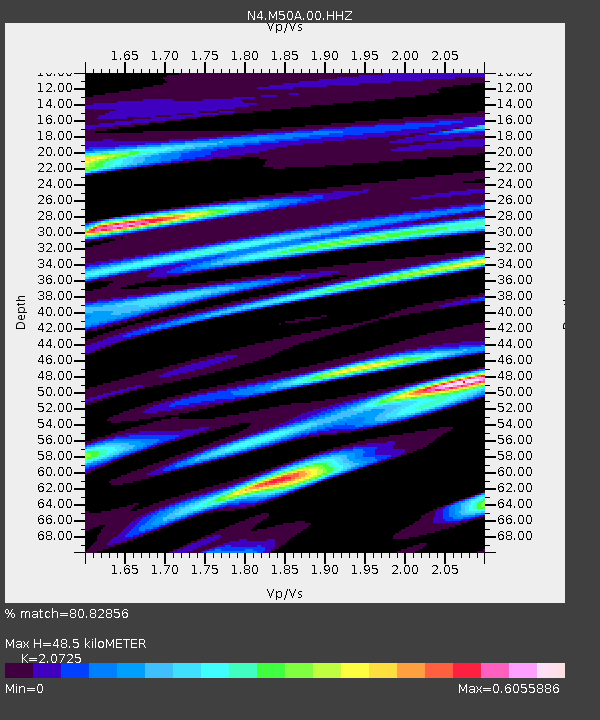
| Estimated Moho Depth: |
48.5 km |
| Estimated Crust Vp/Vs: |
2.07 |
| Assumed Crust Vp: |
6.498 km/s |
| Estimated Crust Vs: |
3.135 km/s |
| Estimated Crust Poisson's Ratio: |
0.35 |
|
| Radial Match: |
80.82856 % |
| Radial Bump: |
400 |
| Transverse Match: |
59.18612 % |
| Transverse Bump: |
400 |
| SOD ConfigId: |
28208852 |
| Insert Time: |
2022-07-08 00:23:59.308 +0000 |
| GWidth: |
2.5 |
| Max Bumps: |
400 |
| Tol: |
0.001 |
|

Signal To Noise
| Channel | StoN | STA | LTA |
| N4:M50A:00:HHZ:20220624T00:10:41.878998Z | 9.558422 | 8.899807E-7 | 9.3109584E-8 |
| N4:M50A:00:HH1:20220624T00:10:41.878998Z | 1.6627697 | 3.8845013E-7 | 2.3361632E-7 |
| N4:M50A:00:HH2:20220624T00:10:41.878998Z | 1.5807182 | 3.31248E-7 | 2.0955538E-7 |
| Arrivals |
| Ps | 8.3 SECOND |
| PpPs | 22 SECOND |
| PsPs/PpSs | 30 SECOND |


