You are here: Home > Network List > N4 - Central and EAstern US Network Stations List
> Station P46A Rosedale, IN, USA > Earthquake Result Viewer
P46A Rosedale, IN, USA - Earthquake Result Viewer
| Earthquake location: |
Southern East Pacific Rise |
| Earthquake latitude/longitude: |
-21.4/-110.2 |
| Earthquake time(UTC): |
2022/06/24 (175) 00:00:18 GMT |
| Earthquake Depth: |
10 km |
| Earthquake Magnitude: |
5.8 mww |
| Earthquake Catalog/Contributor: |
NEIC PDE/us |
|
| Network: |
N4 Central and EAstern US Network |
| Station: |
P46A Rosedale, IN, USA |
| Lat/Lon: |
39.62 N/87.21 W |
| Elevation: |
194 m |
|
| Distance: |
64.3 deg |
| Az: |
19.546 deg |
| Baz: |
203.813 deg |
| Ray Param: |
0.058978666 |
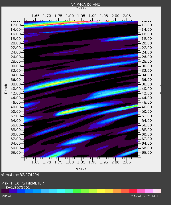
| Estimated Moho Depth: |
10.75 km |
| Estimated Crust Vp/Vs: |
1.86 |
| Assumed Crust Vp: |
6.444 km/s |
| Estimated Crust Vs: |
3.469 km/s |
| Estimated Crust Poisson's Ratio: |
0.30 |
|
| Radial Match: |
83.976494 % |
| Radial Bump: |
400 |
| Transverse Match: |
53.477097 % |
| Transverse Bump: |
400 |
| SOD ConfigId: |
28208852 |
| Insert Time: |
2022-07-08 00:24:25.301 +0000 |
| GWidth: |
2.5 |
| Max Bumps: |
400 |
| Tol: |
0.001 |
|

Signal To Noise
| Channel | StoN | STA | LTA |
| N4:P46A:00:HHZ:20220624T00:10:22.720001Z | 13.220315 | 1.1151556E-6 | 8.435166E-8 |
| N4:P46A:00:HH1:20220624T00:10:22.720001Z | 5.2659044 | 4.831449E-7 | 9.1749655E-8 |
| N4:P46A:00:HH2:20220624T00:10:22.720001Z | 1.8722928 | 2.1690671E-7 | 1.1585085E-7 |
| Arrivals |
| Ps | 1.5 SECOND |
| PpPs | 4.6 SECOND |
| PsPs/PpSs | 6.1 SECOND |


