You are here: Home > Network List > N4 - Central and EAstern US Network Stations List
> Station Y49A Blount Mountain, AL, USA > Earthquake Result Viewer
Y49A Blount Mountain, AL, USA - Earthquake Result Viewer
| Earthquake location: |
Southern East Pacific Rise |
| Earthquake latitude/longitude: |
-21.4/-110.2 |
| Earthquake time(UTC): |
2022/06/24 (175) 00:00:18 GMT |
| Earthquake Depth: |
10 km |
| Earthquake Magnitude: |
5.8 mww |
| Earthquake Catalog/Contributor: |
NEIC PDE/us |
|
| Network: |
N4 Central and EAstern US Network |
| Station: |
Y49A Blount Mountain, AL, USA |
| Lat/Lon: |
33.86 N/86.41 W |
| Elevation: |
362 m |
|
| Distance: |
59.4 deg |
| Az: |
22.941 deg |
| Baz: |
205.889 deg |
| Ray Param: |
0.0622186 |
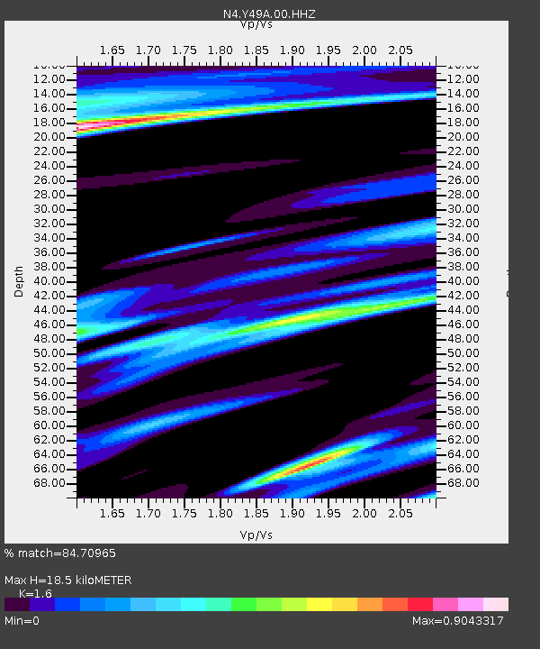
| Estimated Moho Depth: |
18.5 km |
| Estimated Crust Vp/Vs: |
1.60 |
| Assumed Crust Vp: |
6.565 km/s |
| Estimated Crust Vs: |
4.103 km/s |
| Estimated Crust Poisson's Ratio: |
0.18 |
|
| Radial Match: |
84.70965 % |
| Radial Bump: |
400 |
| Transverse Match: |
63.28962 % |
| Transverse Bump: |
400 |
| SOD ConfigId: |
28208852 |
| Insert Time: |
2022-07-08 00:25:19.064 +0000 |
| GWidth: |
2.5 |
| Max Bumps: |
400 |
| Tol: |
0.001 |
|

Signal To Noise
| Channel | StoN | STA | LTA |
| N4:Y49A:00:HHZ:20220624T00:09:49.478973Z | 6.1010423 | 9.3126454E-7 | 1.5264023E-7 |
| N4:Y49A:00:HH1:20220624T00:09:49.478973Z | 6.332041 | 4.4438997E-7 | 7.018116E-8 |
| N4:Y49A:00:HH2:20220624T00:09:49.478973Z | 2.1814845 | 2.1245376E-7 | 9.738953E-8 |
| Arrivals |
| Ps | 1.8 SECOND |
| PpPs | 6.9 SECOND |
| PsPs/PpSs | 8.7 SECOND |


