You are here: Home > Network List > UU - University of Utah Regional Network Stations List
> Station NOQ North Oquirrh Mountains, UT, USA > Earthquake Result Viewer
NOQ North Oquirrh Mountains, UT, USA - Earthquake Result Viewer
| Earthquake location: |
Andreanof Islands, Aleutian Is. |
| Earthquake latitude/longitude: |
51.4/-178.1 |
| Earthquake time(UTC): |
2018/08/15 (227) 21:56:54 GMT |
| Earthquake Depth: |
20 km |
| Earthquake Magnitude: |
6.6 Mww |
| Earthquake Catalog/Contributor: |
NEIC PDE/us |
|
| Network: |
UU University of Utah Regional Network |
| Station: |
NOQ North Oquirrh Mountains, UT, USA |
| Lat/Lon: |
40.65 N/112.12 W |
| Elevation: |
1622 m |
|
| Distance: |
45.5 deg |
| Az: |
76.697 deg |
| Baz: |
306.807 deg |
| Ray Param: |
0.07117763 |
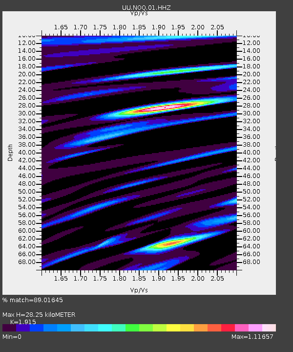
| Estimated Moho Depth: |
28.25 km |
| Estimated Crust Vp/Vs: |
1.91 |
| Assumed Crust Vp: |
6.276 km/s |
| Estimated Crust Vs: |
3.277 km/s |
| Estimated Crust Poisson's Ratio: |
0.31 |
|
| Radial Match: |
89.01645 % |
| Radial Bump: |
358 |
| Transverse Match: |
80.63667 % |
| Transverse Bump: |
400 |
| SOD ConfigId: |
2825771 |
| Insert Time: |
2018-08-29 22:14:28.928 +0000 |
| GWidth: |
2.5 |
| Max Bumps: |
400 |
| Tol: |
0.001 |
|

Signal To Noise
| Channel | StoN | STA | LTA |
| UU:NOQ:01:HHZ:20180815T22:04:42.260011Z | 25.334421 | 6.7648116E-8 | 2.6702056E-9 |
| UU:NOQ:01:HHN:20180815T22:04:42.260011Z | 10.13084 | 2.5969412E-8 | 2.5634017E-9 |
| UU:NOQ:01:HHE:20180815T22:04:42.260011Z | 7.303071 | 2.6288635E-8 | 3.5996688E-9 |
| Arrivals |
| Ps | 4.4 SECOND |
| PpPs | 12 SECOND |
| PsPs/PpSs | 17 SECOND |


