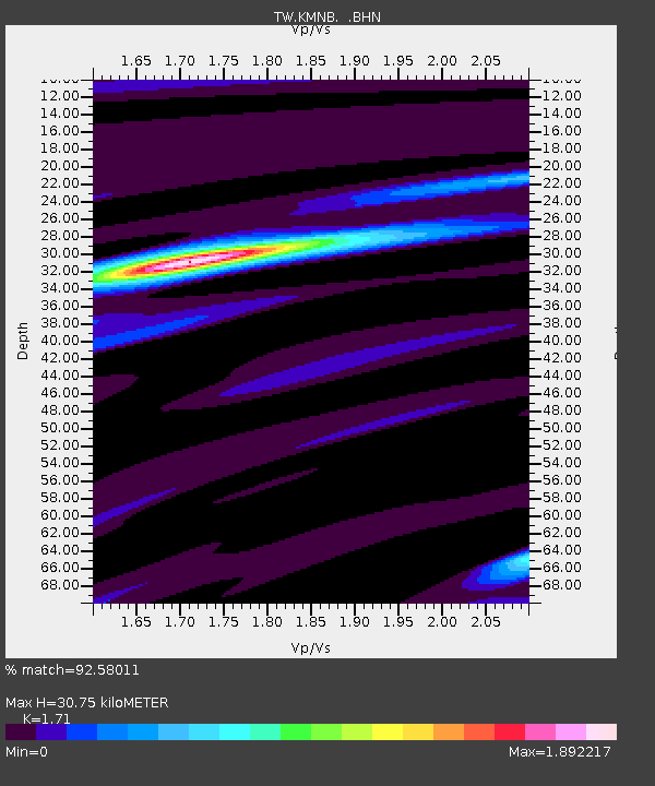
KMNB KING-MEN - Earthquake Result Viewer

Earthquake location: Near N Coast Of New Guinea, P.N.G.
Earthquake latitude/longitude: -3.2/142.4
Earthquake time(UTC): 2002/01/10 (010) 11:14:56 GMT
Earthquake Depth: 11 km
Earthquake Magnitude: 6.0 MB, 6.6 MS, 6.7 MW, 6.6 MW
Earthquake Catalog/Contributor: WHDF/NEIC
Network: TW Broadband Array in Taiwan for Seismology
Station: KMNB KING-MEN
Lat/Lon: 24.46 N/118.39 E
Elevation: 43 m
Distance: 36.1 deg
Az: 320.945 deg
Baz: 136.342 deg
Ray Param: 0.076864064
Estimated Moho Depth: 30.75 km
Estimated Crust Vp/Vs: 1.71
Assumed Crust Vp: 6.472 km/s
Estimated Crust Vs: 3.785 km/s
Estimated Crust Poisson's Ratio: 0.24
Radial Match: 92.58011 %
Radial Bump: 332
Transverse Match: 66.769806 %
Transverse Bump: 400
SOD ConfigId: 20082
Insert Time: 2010-03-09 21:34:47.026 +0000
GWidth: 2.5
Max Bumps: 400
Tol: 0.001

Signal To Noise

ChannelStoNSTALTA
TW:KMNB: :BHN:20020110T11:21:27.906013Z6.9790677.1680347E-71.0270764E-7
TW:KMNB: :BHE:20020110T11:21:27.906013Z4.86597167.339536E-71.5083391E-7
TW:KMNB: :BHZ:20020110T11:21:27.906013Z11.7367561.4893416E-61.268955E-7
Arrivals
Ps3.7 SECOND
PpPs12 SECOND
PsPs/PpSs16 SECOND