You are here: Home > Network List > UU - University of Utah Regional Network Stations List
> Station WPUT Wasatch Plateau, UT,USA > Earthquake Result Viewer
WPUT Wasatch Plateau, UT,USA - Earthquake Result Viewer

| Earthquake location: |
Andreanof Islands, Aleutian Is. |
| Earthquake latitude/longitude: |
51.4/-178.1 |
| Earthquake time(UTC): |
2018/08/15 (227) 21:56:54 GMT |
| Earthquake Depth: |
20 km |
| Earthquake Magnitude: |
6.6 Mww |
| Earthquake Catalog/Contributor: |
NEIC PDE/us |
|
| Network: |
UU University of Utah Regional Network |
| Station: |
WPUT Wasatch Plateau, UT,USA |
| Lat/Lon: |
39.00 N/111.36 W |
| Elevation: |
2618 m |
|
| Distance: |
47.0 deg |
| Az: |
78.017 deg |
| Baz: |
308.206 deg |
| Ray Param: |
0.07024079 |
| Estimated Moho Depth: |
49.75 km |
| Estimated Crust Vp/Vs: |
1.67 |
| Assumed Crust Vp: |
6.207 km/s |
| Estimated Crust Vs: |
3.722 km/s |
| Estimated Crust Poisson's Ratio: |
0.22 |
|
| Radial Match: |
82.53893 % |
| Radial Bump: |
400 |
| Transverse Match: |
70.71813 % |
| Transverse Bump: |
400 |
| SOD ConfigId: |
2825771 |
| Insert Time: |
2018-08-29 22:14:56.695 +0000 |
| GWidth: |
2.5 |
| Max Bumps: |
400 |
| Tol: |
0.001 |
|
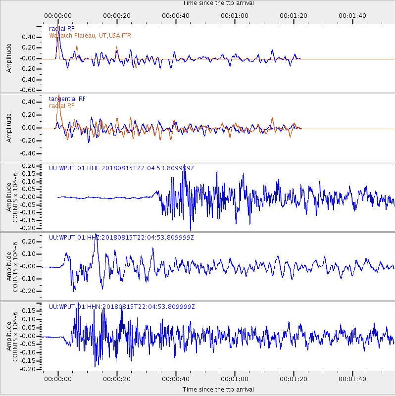
Signal To Noise
| Channel | StoN | STA | LTA |
| UU:WPUT:01:HHZ:20180815T22:04:53.809999Z | 22.699553 | 6.061527E-8 | 2.6703288E-9 |
| UU:WPUT:01:HHN:20180815T22:04:53.809999Z | 6.265546 | 2.3197995E-8 | 3.7024699E-9 |
| UU:WPUT:01:HHE:20180815T22:04:53.809999Z | 5.622928 | 1.931667E-8 | 3.4353398E-9 |
| Arrivals |
| Ps | 5.7 SECOND |
| PpPs | 20 SECOND |
| PsPs/PpSs | 26 SECOND |


