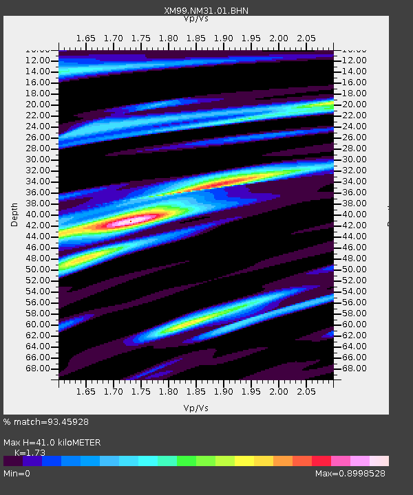
NM31 NewMexico31 - Earthquake Result Viewer
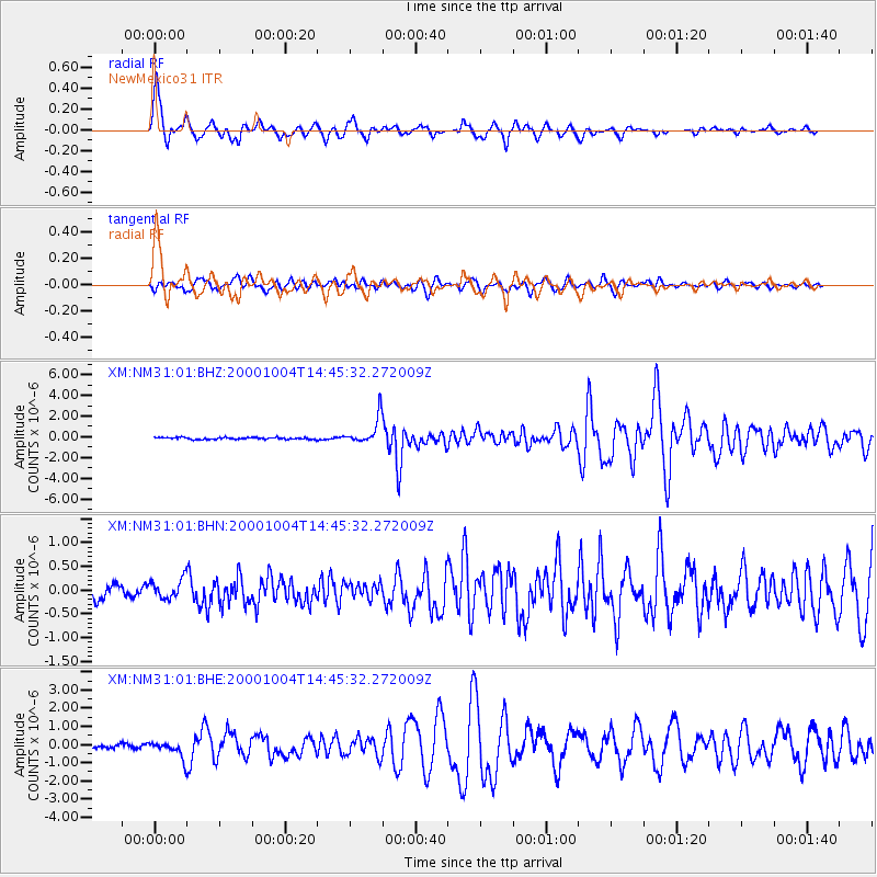
Earthquake location: Windward Islands
Earthquake latitude/longitude: 11.1/-62.6
Earthquake time(UTC): 2000/10/04 (278) 14:37:44 GMT
Earthquake Depth: 110 km
Earthquake Magnitude: 5.6 MB, 5.4 MS, 6.1 MW, 5.9 MD
Earthquake Catalog/Contributor: WHDF/NEIC
Network: XM Rio Grande Seismic Transect
Station: NM31 NewMexico31
Lat/Lon: 34.85 N/107.10 W
Elevation: 1676 m
Distance: 46.8 deg
Az: 307.704 deg
Baz: 109.241 deg
Ray Param: 0.070017315
Estimated Moho Depth: 41.0 km
Estimated Crust Vp/Vs: 1.73
Assumed Crust Vp: 6.502 km/s
Estimated Crust Vs: 3.758 km/s
Estimated Crust Poisson's Ratio: 0.25
Radial Match: 93.45928 %
Radial Bump: 400
Transverse Match: 82.60264 %
Transverse Bump: 400
SOD ConfigId: 16820
Insert Time: 2010-02-26 17:30:56.214 +0000
GWidth: 2.5
Max Bumps: 400
Tol: 0.001

Signal To Noise

ChannelStoNSTALTA
XM:NM31:01:BHN:20001004T14:45:32.272009Z2.15429832.0980458E-79.738883E-8
XM:NM31:01:BHE:20001004T14:45:32.272009Z4.9515144.552159E-79.19347E-8
XM:NM31:01:BHZ:20001004T14:45:32.272009Z14.16621.2749404E-68.999875E-8
Arrivals
Ps4.9 SECOND
PpPs16 SECOND
PsPs/PpSs21 SECOND