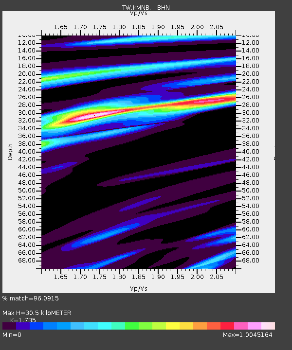
KMNB KING-MEN - Earthquake Result Viewer

Earthquake location: Timor Region
Earthquake latitude/longitude: -8.2/124.9
Earthquake time(UTC): 2004/11/11 (316) 21:26:41 GMT
Earthquake Depth: 10 km
Earthquake Magnitude: 6.5 MB, 7.3 MS, 7.5 MW, 7.4 MW
Earthquake Catalog/Contributor: WHDF/NEIC
Network: TW Broadband Array in Taiwan for Seismology
Station: KMNB KING-MEN
Lat/Lon: 24.46 N/118.39 E
Elevation: 43 m
Distance: 33.0 deg
Az: 349.125 deg
Baz: 168.172 deg
Ray Param: 0.07839718
Estimated Moho Depth: 30.5 km
Estimated Crust Vp/Vs: 1.74
Assumed Crust Vp: 6.472 km/s
Estimated Crust Vs: 3.73 km/s
Estimated Crust Poisson's Ratio: 0.25
Radial Match: 96.0915 %
Radial Bump: 288
Transverse Match: 81.322136 %
Transverse Bump: 400
SOD ConfigId: 2459
Insert Time: 2010-03-09 21:35:17.974 +0000
GWidth: 2.5
Max Bumps: 400
Tol: 0.001

Signal To Noise

ChannelStoNSTALTA
TW:KMNB: :BHN:20041111T21:32:45.794012Z4.79542351.5022524E-63.1326795E-7
TW:KMNB: :BHE:20041111T21:32:45.794012Z2.21781953.2965752E-71.4864038E-7
TW:KMNB: :BHZ:20041111T21:32:45.794012Z4.8818432.5428496E-65.2087904E-7
Arrivals
Ps3.8 SECOND
PpPs12 SECOND
PsPs/PpSs16 SECOND