You are here: Home > Network List > TW - Broadband Array in Taiwan for Seismology Stations List
> Station KMNB KING-MEN > Earthquake Result Viewer
KMNB KING-MEN - Earthquake Result Viewer
| Earthquake location: |
Kermadec Islands Region |
| Earthquake latitude/longitude: |
-31.5/-178.8 |
| Earthquake time(UTC): |
2009/05/16 (136) 00:53:52 GMT |
| Earthquake Depth: |
55 km |
| Earthquake Magnitude: |
6.1 MB, 6.5 MW, 6.3 MW |
| Earthquake Catalog/Contributor: |
WHDF/NEIC |
|
| Network: |
TW Broadband Array in Taiwan for Seismology |
| Station: |
KMNB KING-MEN |
| Lat/Lon: |
24.46 N/118.39 E |
| Elevation: |
43 m |
|
| Distance: |
81.9 deg |
| Az: |
305.03 deg |
| Baz: |
129.878 deg |
| Ray Param: |
0.047175873 |
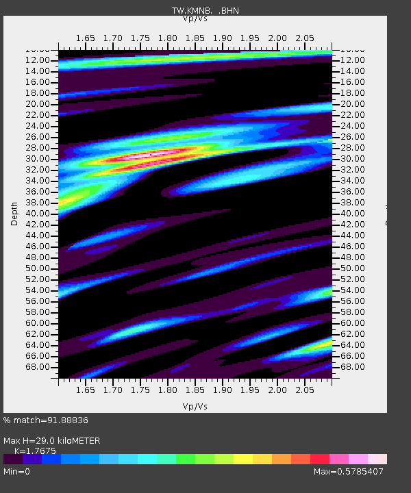
| Estimated Moho Depth: |
29.0 km |
| Estimated Crust Vp/Vs: |
1.77 |
| Assumed Crust Vp: |
6.472 km/s |
| Estimated Crust Vs: |
3.662 km/s |
| Estimated Crust Poisson's Ratio: |
0.26 |
|
| Radial Match: |
91.88836 % |
| Radial Bump: |
400 |
| Transverse Match: |
85.30208 % |
| Transverse Bump: |
400 |
| SOD ConfigId: |
2760 |
| Insert Time: |
2010-03-09 21:35:28.841 +0000 |
| GWidth: |
2.5 |
| Max Bumps: |
400 |
| Tol: |
0.001 |
|

Signal To Noise
| Channel | StoN | STA | LTA |
| TW:KMNB: :BHN:20090516T01:05:35.169016Z | 16.49547 | 8.1902745E-6 | 4.9651663E-7 |
| TW:KMNB: :BHE:20090516T01:05:35.169016Z | 5.757436 | 1.8334151E-6 | 3.18443E-7 |
| TW:KMNB: :BHZ:20090516T01:05:35.169016Z | 6.855076 | 2.4752894E-6 | 3.6108855E-7 |
| Arrivals |
| Ps | 3.5 SECOND |
| PpPs | 12 SECOND |
| PsPs/PpSs | 16 SECOND |


