You are here: Home > Network List > XM99 - Rio Grande Seismic Transect Stations List
> Station NM31 NewMexico31 > Earthquake Result Viewer
NM31 NewMexico31 - Earthquake Result Viewer
| Earthquake location: |
Kodiak Island Region, Alaska |
| Earthquake latitude/longitude: |
57.4/-154.5 |
| Earthquake time(UTC): |
1999/12/06 (340) 23:12:33 GMT |
| Earthquake Depth: |
66 km |
| Earthquake Magnitude: |
6.8 MB, 7.0 MW, 7.0 ML |
| Earthquake Catalog/Contributor: |
WHDF/NEIC |
|
| Network: |
XM Rio Grande Seismic Transect |
| Station: |
NM31 NewMexico31 |
| Lat/Lon: |
34.85 N/107.10 W |
| Elevation: |
1676 m |
|
| Distance: |
38.8 deg |
| Az: |
104.841 deg |
| Baz: |
320.504 deg |
| Ray Param: |
0.07517525 |
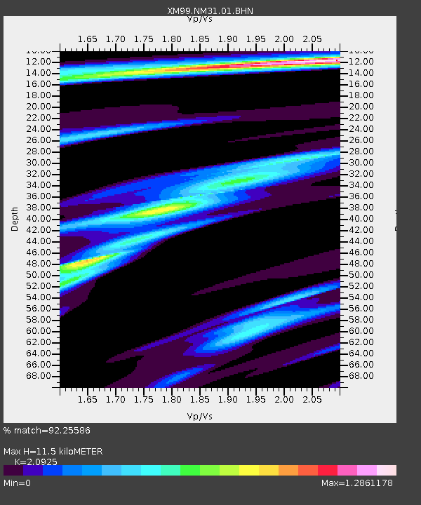
| Estimated Moho Depth: |
11.5 km |
| Estimated Crust Vp/Vs: |
2.09 |
| Assumed Crust Vp: |
6.502 km/s |
| Estimated Crust Vs: |
3.107 km/s |
| Estimated Crust Poisson's Ratio: |
0.35 |
|
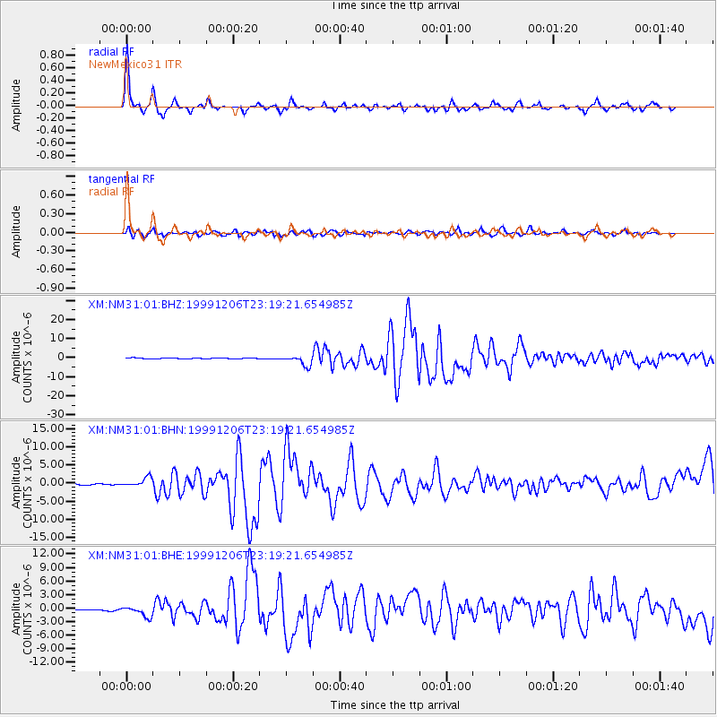
| Radial Match: |
92.25586 % |
| Radial Bump: |
348 |
| Transverse Match: |
81.23443 % |
| Transverse Bump: |
400 |
| SOD ConfigId: |
27569 |
| Insert Time: |
2010-02-26 17:31:06.415 +0000 |
| GWidth: |
2.5 |
| Max Bumps: |
400 |
| Tol: |
0.001 |
|
Signal To Noise
| Channel | StoN | STA | LTA |
| XM:NM31:01:BHN:19991206T23:19:21.654985Z | 6.8296914 | 1.3666091E-6 | 2.0009823E-7 |
| XM:NM31:01:BHE:19991206T23:19:21.654985Z | 6.6091247 | 1.1539474E-6 | 1.7459912E-7 |
| XM:NM31:01:BHZ:19991206T23:19:21.654985Z | 12.515978 | 2.726309E-6 | 2.1782631E-7 |
| Arrivals |
| Ps | 2.1 SECOND |
| PpPs | 5.1 SECOND |
| PsPs/PpSs | 7.2 SECOND |


