You are here: Home > Network List > AG - Arkansas Seismic Network Stations List
> Station HHAR Hobbs,AR > Earthquake Result Viewer
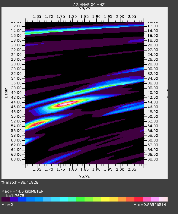
HHAR Hobbs,AR - Earthquake Result Viewer
| Earthquake location: |
Off Coast Of Peru |
| Earthquake latitude/longitude: |
-17.2/-73.8 |
| Earthquake time(UTC): |
2022/06/26 (177) 02:02:35 GMT |
| Earthquake Depth: |
15 km |
| Earthquake Magnitude: |
5.7 mww |
| Earthquake Catalog/Contributor: |
NEIC PDE/us |
|
| Network: |
AG Arkansas Seismic Network |
| Station: |
HHAR Hobbs,AR |
| Lat/Lon: |
36.28 N/93.94 W |
| Elevation: |
421 m |
|
| Distance: |
56.5 deg |
| Az: |
340.475 deg |
| Baz: |
156.709 deg |
| Ray Param: |
0.064099535 |
| Estimated Moho Depth: |
44.5 km |
| Estimated Crust Vp/Vs: |
1.77 |
| Assumed Crust Vp: |
6.53 km/s |
| Estimated Crust Vs: |
3.695 km/s |
| Estimated Crust Poisson's Ratio: |
0.26 |
|
| Radial Match: |
88.41826 % |
| Radial Bump: |
214 |
| Transverse Match: |
77.37116 % |
| Transverse Bump: |
399 |
| SOD ConfigId: |
28208852 |
| Insert Time: |
2022-07-10 02:05:12.931 +0000 |
| GWidth: |
2.5 |
| Max Bumps: |
400 |
| Tol: |
0.001 |
|

Signal To Noise
| Channel | StoN | STA | LTA |
| AG:HHAR:00:HHZ:20220626T02:11:46.009999Z | 10.312113 | 6.447613E-7 | 6.2524656E-8 |
| AG:HHAR:00:HHN:20220626T02:11:46.009999Z | 5.219101 | 2.029877E-7 | 3.8893234E-8 |
| AG:HHAR:00:HHE:20220626T02:11:46.009999Z | 2.5429416 | 1.9037601E-7 | 7.486449E-8 |
| Arrivals |
| Ps | 5.5 SECOND |
| PpPs | 18 SECOND |
| PsPs/PpSs | 23 SECOND |


