You are here: Home > Network List > LD - Lamont-Doherty Cooperative Seismographic Network Stations List
> Station GEDE Greenville, DE, USA > Earthquake Result Viewer
GEDE Greenville, DE, USA - Earthquake Result Viewer
| Earthquake location: |
Off Coast Of Peru |
| Earthquake latitude/longitude: |
-17.2/-73.8 |
| Earthquake time(UTC): |
2022/06/26 (177) 02:02:35 GMT |
| Earthquake Depth: |
15 km |
| Earthquake Magnitude: |
5.7 mww |
| Earthquake Catalog/Contributor: |
NEIC PDE/us |
|
| Network: |
LD Lamont-Doherty Cooperative Seismographic Network |
| Station: |
GEDE Greenville, DE, USA |
| Lat/Lon: |
39.81 N/75.64 W |
| Elevation: |
105 m |
|
| Distance: |
56.7 deg |
| Az: |
358.277 deg |
| Baz: |
177.862 deg |
| Ray Param: |
0.06394993 |
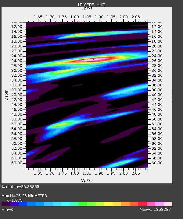
| Estimated Moho Depth: |
25.25 km |
| Estimated Crust Vp/Vs: |
1.88 |
| Assumed Crust Vp: |
6.287 km/s |
| Estimated Crust Vs: |
3.353 km/s |
| Estimated Crust Poisson's Ratio: |
0.30 |
|
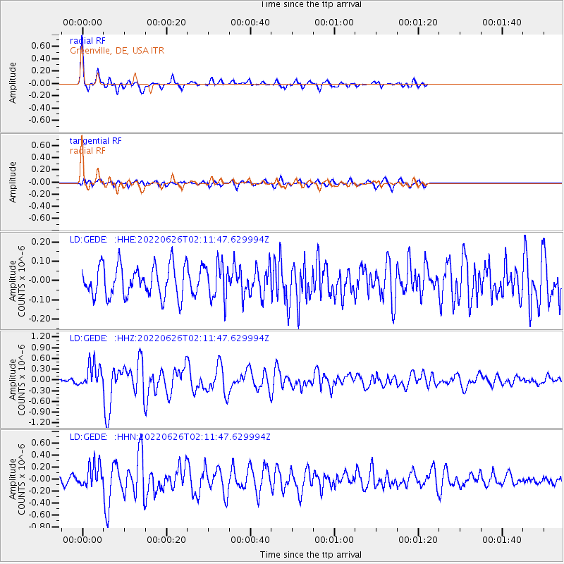
| Radial Match: |
85.38865 % |
| Radial Bump: |
389 |
| Transverse Match: |
64.26856 % |
| Transverse Bump: |
400 |
| SOD ConfigId: |
28208852 |
| Insert Time: |
2022-07-10 02:18:17.104 +0000 |
| GWidth: |
2.5 |
| Max Bumps: |
400 |
| Tol: |
0.001 |
|
Signal To Noise
| Channel | StoN | STA | LTA |
| LD:GEDE: :HHZ:20220626T02:11:47.629994Z | 4.4884267 | 3.3540024E-7 | 7.472557E-8 |
| LD:GEDE: :HHN:20220626T02:11:47.629994Z | 2.5332415 | 1.9358257E-7 | 7.641694E-8 |
| LD:GEDE: :HHE:20220626T02:11:47.629994Z | 1.185712 | 9.427065E-8 | 7.950552E-8 |
| Arrivals |
| Ps | 3.7 SECOND |
| PpPs | 11 SECOND |
| PsPs/PpSs | 15 SECOND |


