You are here: Home > Network List > MB - Montana Regional Seismic Network Stations List
> Station SRMT Salmond Ranch > Earthquake Result Viewer
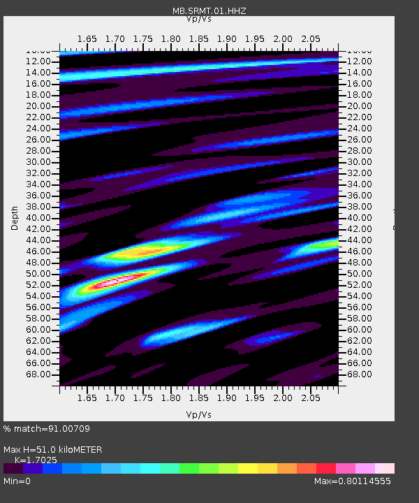
SRMT Salmond Ranch - Earthquake Result Viewer
| Earthquake location: |
Off Coast Of Peru |
| Earthquake latitude/longitude: |
-17.2/-73.8 |
| Earthquake time(UTC): |
2022/06/26 (177) 02:02:35 GMT |
| Earthquake Depth: |
15 km |
| Earthquake Magnitude: |
5.7 mww |
| Earthquake Catalog/Contributor: |
NEIC PDE/us |
|
| Network: |
MB Montana Regional Seismic Network |
| Station: |
SRMT Salmond Ranch |
| Lat/Lon: |
47.78 N/112.61 W |
| Elevation: |
1522 m |
|
| Distance: |
73.4 deg |
| Az: |
333.806 deg |
| Baz: |
141.275 deg |
| Ray Param: |
0.053017236 |
| Estimated Moho Depth: |
51.0 km |
| Estimated Crust Vp/Vs: |
1.70 |
| Assumed Crust Vp: |
6.353 km/s |
| Estimated Crust Vs: |
3.732 km/s |
| Estimated Crust Poisson's Ratio: |
0.24 |
|
| Radial Match: |
91.00709 % |
| Radial Bump: |
329 |
| Transverse Match: |
71.646996 % |
| Transverse Bump: |
400 |
| SOD ConfigId: |
28208852 |
| Insert Time: |
2022-07-10 02:18:46.318 +0000 |
| GWidth: |
2.5 |
| Max Bumps: |
400 |
| Tol: |
0.001 |
|

Signal To Noise
| Channel | StoN | STA | LTA |
| MB:SRMT:01:HHZ:20220626T02:13:35.840016Z | 8.699846 | 6.8954057E-7 | 7.9258946E-8 |
| MB:SRMT:01:HHN:20220626T02:13:35.840016Z | 3.4215987 | 1.8379833E-7 | 5.371709E-8 |
| MB:SRMT:01:HHE:20220626T02:13:35.840016Z | 5.054428 | 2.3722255E-7 | 4.6933607E-8 |
| Arrivals |
| Ps | 5.8 SECOND |
| PpPs | 21 SECOND |
| PsPs/PpSs | 27 SECOND |


