You are here: Home > Network List > WY - Yellowstone Wyoming Seismic Network Stations List
> Station YTP The Promontory, YNP, WY, USA > Earthquake Result Viewer
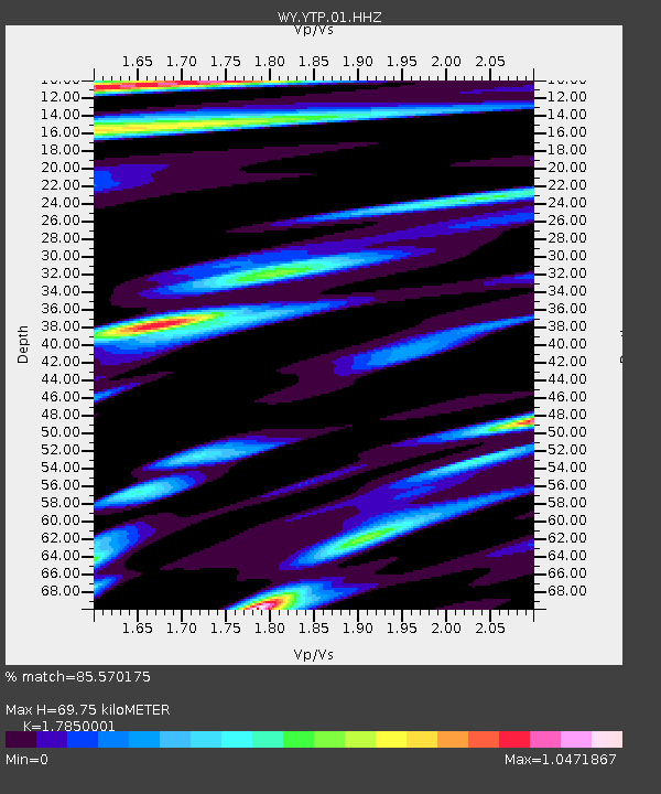
YTP The Promontory, YNP, WY, USA - Earthquake Result Viewer
| Earthquake location: |
Volcano Islands, Japan Region |
| Earthquake latitude/longitude: |
23.4/143.3 |
| Earthquake time(UTC): |
2018/08/16 (228) 18:22:53 GMT |
| Earthquake Depth: |
20 km |
| Earthquake Magnitude: |
6.3 Mww |
| Earthquake Catalog/Contributor: |
NEIC PDE/us |
|
| Network: |
WY Yellowstone Wyoming Seismic Network |
| Station: |
YTP The Promontory, YNP, WY, USA |
| Lat/Lon: |
44.39 N/110.29 W |
| Elevation: |
2384 m |
|
| Distance: |
84.8 deg |
| Az: |
43.672 deg |
| Baz: |
297.788 deg |
| Ray Param: |
0.045170248 |
| Estimated Moho Depth: |
69.75 km |
| Estimated Crust Vp/Vs: |
1.79 |
| Assumed Crust Vp: |
6.35 km/s |
| Estimated Crust Vs: |
3.557 km/s |
| Estimated Crust Poisson's Ratio: |
0.27 |
|
| Radial Match: |
85.570175 % |
| Radial Bump: |
400 |
| Transverse Match: |
85.78661 % |
| Transverse Bump: |
400 |
| SOD ConfigId: |
2825771 |
| Insert Time: |
2018-08-30 18:38:21.289 +0000 |
| GWidth: |
2.5 |
| Max Bumps: |
400 |
| Tol: |
0.001 |
|

Signal To Noise
| Channel | StoN | STA | LTA |
| WY:YTP:01:HHZ:20180816T18:34:55.047998Z | 0.59044147 | 6.460724E-9 | 1.0942192E-8 |
| WY:YTP:01:HHN:20180816T18:34:55.047998Z | 1.2513249 | 6.1962417E-9 | 4.9517452E-9 |
| WY:YTP:01:HHE:20180816T18:34:55.047998Z | 1.1557184 | 7.946757E-9 | 6.876032E-9 |
| Arrivals |
| Ps | 8.8 SECOND |
| PpPs | 30 SECOND |
| PsPs/PpSs | 39 SECOND |


