You are here: Home > Network List > TX - Texas Seismological Network Stations List
> Station PB28 Culberson South > Earthquake Result Viewer
PB28 Culberson South - Earthquake Result Viewer
| Earthquake location: |
Off Coast Of Peru |
| Earthquake latitude/longitude: |
-17.2/-73.8 |
| Earthquake time(UTC): |
2022/06/26 (177) 02:02:35 GMT |
| Earthquake Depth: |
15 km |
| Earthquake Magnitude: |
5.7 mww |
| Earthquake Catalog/Contributor: |
NEIC PDE/us |
|
| Network: |
TX Texas Seismological Network |
| Station: |
PB28 Culberson South |
| Lat/Lon: |
31.67 N/104.50 W |
| Elevation: |
1204 m |
|
| Distance: |
56.8 deg |
| Az: |
328.623 deg |
| Baz: |
144.286 deg |
| Ray Param: |
0.06388101 |
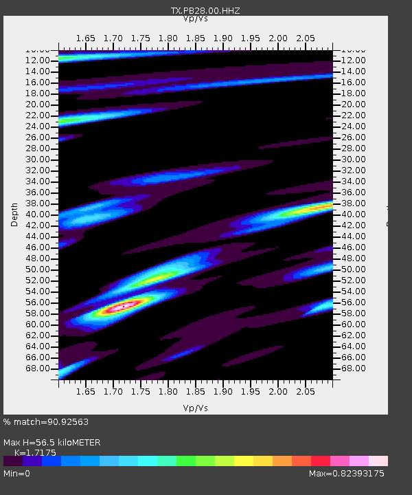
| Estimated Moho Depth: |
56.5 km |
| Estimated Crust Vp/Vs: |
1.72 |
| Assumed Crust Vp: |
6.361 km/s |
| Estimated Crust Vs: |
3.703 km/s |
| Estimated Crust Poisson's Ratio: |
0.24 |
|
| Radial Match: |
90.92563 % |
| Radial Bump: |
325 |
| Transverse Match: |
84.89329 % |
| Transverse Bump: |
400 |
| SOD ConfigId: |
28208852 |
| Insert Time: |
2022-07-10 02:29:44.610 +0000 |
| GWidth: |
2.5 |
| Max Bumps: |
400 |
| Tol: |
0.001 |
|

Signal To Noise
| Channel | StoN | STA | LTA |
| TX:PB28:00:HHZ:20220626T02:11:48.350026Z | 7.1057224 | 3.970204E-7 | 5.5873333E-8 |
| TX:PB28:00:HH1:20220626T02:11:48.350026Z | 3.1127558 | 1.5858969E-7 | 5.0948323E-8 |
| TX:PB28:00:HH2:20220626T02:11:48.350026Z | 2.6950336 | 9.911498E-8 | 3.67769E-8 |
| Arrivals |
| Ps | 6.7 SECOND |
| PpPs | 23 SECOND |
| PsPs/PpSs | 30 SECOND |


