You are here: Home > Network List > UU - University of Utah Regional Network Stations List
> Station FOR1 Milford Southwest, UT, USA > Earthquake Result Viewer
FOR1 Milford Southwest, UT, USA - Earthquake Result Viewer
| Earthquake location: |
Off Coast Of Peru |
| Earthquake latitude/longitude: |
-17.2/-73.8 |
| Earthquake time(UTC): |
2022/06/26 (177) 02:02:35 GMT |
| Earthquake Depth: |
15 km |
| Earthquake Magnitude: |
5.7 mww |
| Earthquake Catalog/Contributor: |
NEIC PDE/us |
|
| Network: |
UU University of Utah Regional Network |
| Station: |
FOR1 Milford Southwest, UT, USA |
| Lat/Lon: |
38.37 N/113.09 W |
| Elevation: |
1642 m |
|
| Distance: |
66.4 deg |
| Az: |
327.078 deg |
| Baz: |
138.626 deg |
| Ray Param: |
0.05761062 |
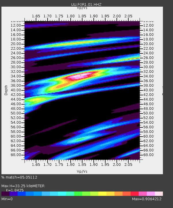
| Estimated Moho Depth: |
33.25 km |
| Estimated Crust Vp/Vs: |
1.84 |
| Assumed Crust Vp: |
6.276 km/s |
| Estimated Crust Vs: |
3.406 km/s |
| Estimated Crust Poisson's Ratio: |
0.29 |
|
| Radial Match: |
85.05112 % |
| Radial Bump: |
323 |
| Transverse Match: |
71.651695 % |
| Transverse Bump: |
392 |
| SOD ConfigId: |
28208852 |
| Insert Time: |
2022-07-10 02:32:39.256 +0000 |
| GWidth: |
2.5 |
| Max Bumps: |
400 |
| Tol: |
0.001 |
|

Signal To Noise
| Channel | StoN | STA | LTA |
| UU:FOR1:01:HHZ:20220626T02:12:53.069997Z | 6.2200637 | 1.6269244E-8 | 2.615607E-9 |
| UU:FOR1:01:HHN:20220626T02:12:53.069997Z | 3.6062353 | 5.3542286E-9 | 1.4847142E-9 |
| UU:FOR1:01:HHE:20220626T02:12:53.069997Z | 6.2612453 | 5.5280127E-9 | 8.8289354E-10 |
| Arrivals |
| Ps | 4.6 SECOND |
| PpPs | 15 SECOND |
| PsPs/PpSs | 19 SECOND |


