You are here: Home > Network List > UU - University of Utah Regional Network Stations List
> Station MOUT Mount Ogden, UT, USA > Earthquake Result Viewer
MOUT Mount Ogden, UT, USA - Earthquake Result Viewer
| Earthquake location: |
Off Coast Of Peru |
| Earthquake latitude/longitude: |
-17.2/-73.8 |
| Earthquake time(UTC): |
2022/06/26 (177) 02:02:35 GMT |
| Earthquake Depth: |
15 km |
| Earthquake Magnitude: |
5.7 mww |
| Earthquake Catalog/Contributor: |
NEIC PDE/us |
|
| Network: |
UU University of Utah Regional Network |
| Station: |
MOUT Mount Ogden, UT, USA |
| Lat/Lon: |
41.20 N/111.88 W |
| Elevation: |
2748 m |
|
| Distance: |
68.0 deg |
| Az: |
329.839 deg |
| Baz: |
140.47 deg |
| Ray Param: |
0.05659954 |
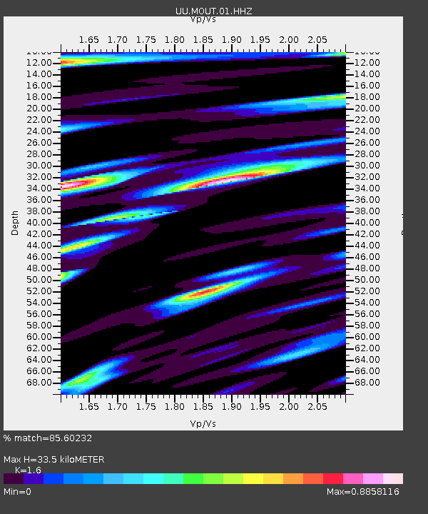
| Estimated Moho Depth: |
33.5 km |
| Estimated Crust Vp/Vs: |
1.60 |
| Assumed Crust Vp: |
6.155 km/s |
| Estimated Crust Vs: |
3.847 km/s |
| Estimated Crust Poisson's Ratio: |
0.18 |
|
| Radial Match: |
85.60232 % |
| Radial Bump: |
400 |
| Transverse Match: |
69.338844 % |
| Transverse Bump: |
400 |
| SOD ConfigId: |
28208852 |
| Insert Time: |
2022-07-10 02:32:56.537 +0000 |
| GWidth: |
2.5 |
| Max Bumps: |
400 |
| Tol: |
0.001 |
|

Signal To Noise
| Channel | StoN | STA | LTA |
| UU:MOUT:01:HHZ:20220626T02:13:02.850026Z | 8.751891 | 4.73274E-7 | 5.407677E-8 |
| UU:MOUT:01:HHN:20220626T02:13:02.850026Z | 3.310797 | 1.9901387E-7 | 6.0110565E-8 |
| UU:MOUT:01:HHE:20220626T02:13:02.850026Z | 2.033628 | 1.8701421E-7 | 9.196087E-8 |
| Arrivals |
| Ps | 3.4 SECOND |
| PpPs | 14 SECOND |
| PsPs/PpSs | 17 SECOND |


