You are here: Home > Network List > AK - Alaska Regional Network Stations List
> Station G23K Bananza Creek, AK, USA > Earthquake Result Viewer
G23K Bananza Creek, AK, USA - Earthquake Result Viewer
| Earthquake location: |
Philippine Islands Region |
| Earthquake latitude/longitude: |
19.1/121.3 |
| Earthquake time(UTC): |
2022/06/30 (181) 18:40:38 GMT |
| Earthquake Depth: |
36 km |
| Earthquake Magnitude: |
5.9 Mww |
| Earthquake Catalog/Contributor: |
NEIC PDE/us |
|
| Network: |
AK Alaska Regional Network |
| Station: |
G23K Bananza Creek, AK, USA |
| Lat/Lon: |
66.71 N/150.02 W |
| Elevation: |
746 m |
|
| Distance: |
72.1 deg |
| Az: |
24.684 deg |
| Baz: |
276.574 deg |
| Ray Param: |
0.05380162 |
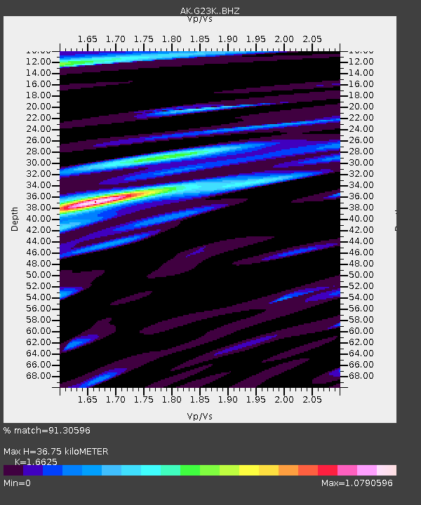
| Estimated Moho Depth: |
36.75 km |
| Estimated Crust Vp/Vs: |
1.66 |
| Assumed Crust Vp: |
6.577 km/s |
| Estimated Crust Vs: |
3.956 km/s |
| Estimated Crust Poisson's Ratio: |
0.22 |
|
| Radial Match: |
91.30596 % |
| Radial Bump: |
400 |
| Transverse Match: |
75.43054 % |
| Transverse Bump: |
400 |
| SOD ConfigId: |
28208852 |
| Insert Time: |
2022-07-14 18:43:34.859 +0000 |
| GWidth: |
2.5 |
| Max Bumps: |
400 |
| Tol: |
0.001 |
|

Signal To Noise
| Channel | StoN | STA | LTA |
| AK:G23K: :BHZ:20220630T18:51:28.139986Z | 44.735245 | 2.0234188E-6 | 4.5230976E-8 |
| AK:G23K: :BHN:20220630T18:51:28.139986Z | 12.030103 | 4.201785E-7 | 3.4927258E-8 |
| AK:G23K: :BHE:20220630T18:51:28.139986Z | 18.115059 | 8.449534E-7 | 4.6643702E-8 |
| Arrivals |
| Ps | 3.9 SECOND |
| PpPs | 14 SECOND |
| PsPs/PpSs | 18 SECOND |


