You are here: Home > Network List > AK - Alaska Regional Network Stations List
> Station R18K Karluk, AK, USA > Earthquake Result Viewer
R18K Karluk, AK, USA - Earthquake Result Viewer
| Earthquake location: |
Philippine Islands Region |
| Earthquake latitude/longitude: |
19.1/121.3 |
| Earthquake time(UTC): |
2022/06/30 (181) 18:40:38 GMT |
| Earthquake Depth: |
36 km |
| Earthquake Magnitude: |
5.9 Mww |
| Earthquake Catalog/Contributor: |
NEIC PDE/us |
|
| Network: |
AK Alaska Regional Network |
| Station: |
R18K Karluk, AK, USA |
| Lat/Lon: |
57.57 N/154.45 W |
| Elevation: |
39 m |
|
| Distance: |
71.1 deg |
| Az: |
34.532 deg |
| Baz: |
275.767 deg |
| Ray Param: |
0.05451467 |
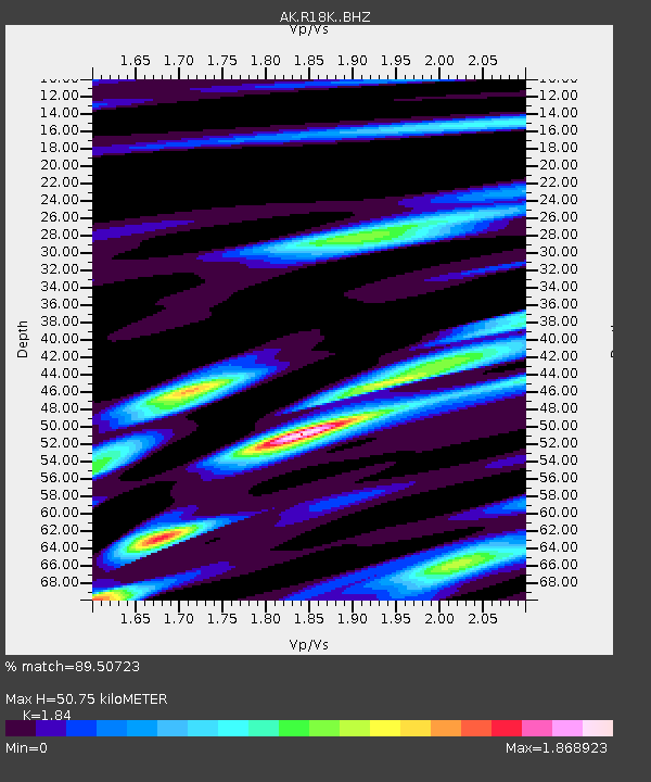
| Estimated Moho Depth: |
50.75 km |
| Estimated Crust Vp/Vs: |
1.84 |
| Assumed Crust Vp: |
6.24 km/s |
| Estimated Crust Vs: |
3.391 km/s |
| Estimated Crust Poisson's Ratio: |
0.29 |
|
| Radial Match: |
89.50723 % |
| Radial Bump: |
400 |
| Transverse Match: |
79.41488 % |
| Transverse Bump: |
400 |
| SOD ConfigId: |
28208852 |
| Insert Time: |
2022-07-14 18:45:38.407 +0000 |
| GWidth: |
2.5 |
| Max Bumps: |
400 |
| Tol: |
0.001 |
|

Signal To Noise
| Channel | StoN | STA | LTA |
| AK:R18K: :BHZ:20220630T18:51:21.620028Z | 27.477734 | 1.5892518E-6 | 5.7837806E-8 |
| AK:R18K: :BHN:20220630T18:51:21.620028Z | 7.042406 | 5.8674743E-7 | 8.331633E-8 |
| AK:R18K: :BHE:20220630T18:51:21.620028Z | 13.864387 | 9.1898005E-7 | 6.62835E-8 |
| Arrivals |
| Ps | 7.1 SECOND |
| PpPs | 22 SECOND |
| PsPs/PpSs | 29 SECOND |


