You are here: Home > Network List > AV - Alaska Volcano Observatory Stations List
> Station AMKA Regional Station, Amchitka Island, Alaska > Earthquake Result Viewer
AMKA Regional Station, Amchitka Island, Alaska - Earthquake Result Viewer

| Earthquake location: |
Philippine Islands Region |
| Earthquake latitude/longitude: |
19.1/121.3 |
| Earthquake time(UTC): |
2022/06/30 (181) 18:40:38 GMT |
| Earthquake Depth: |
36 km |
| Earthquake Magnitude: |
5.9 Mww |
| Earthquake Catalog/Contributor: |
NEIC PDE/us |
|
| Network: |
AV Alaska Volcano Observatory |
| Station: |
AMKA Regional Station, Amchitka Island, Alaska |
| Lat/Lon: |
51.38 N/179.30 E |
| Elevation: |
116 m |
|
| Distance: |
55.5 deg |
| Az: |
40.187 deg |
| Baz: |
256.868 deg |
| Ray Param: |
0.06471021 |
| Estimated Moho Depth: |
37.75 km |
| Estimated Crust Vp/Vs: |
1.88 |
| Assumed Crust Vp: |
6.183 km/s |
| Estimated Crust Vs: |
3.289 km/s |
| Estimated Crust Poisson's Ratio: |
0.30 |
|
| Radial Match: |
80.55475 % |
| Radial Bump: |
400 |
| Transverse Match: |
77.52833 % |
| Transverse Bump: |
400 |
| SOD ConfigId: |
28208852 |
| Insert Time: |
2022-07-14 18:47:38.548 +0000 |
| GWidth: |
2.5 |
| Max Bumps: |
400 |
| Tol: |
0.001 |
|
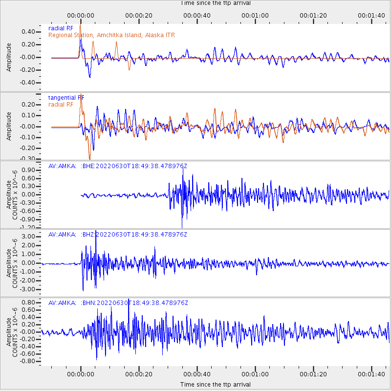
Signal To Noise
| Channel | StoN | STA | LTA |
| AV:AMKA: :BHZ:20220630T18:49:38.478976Z | 37.649715 | 1.1010246E-6 | 2.9243902E-8 |
| AV:AMKA: :BHN:20220630T18:49:38.478976Z | 3.5914228 | 1.4142513E-7 | 3.937858E-8 |
| AV:AMKA: :BHE:20220630T18:49:38.478976Z | 8.057221 | 2.9214092E-7 | 3.6258275E-8 |
| Arrivals |
| Ps | 5.6 SECOND |
| PpPs | 17 SECOND |
| PsPs/PpSs | 22 SECOND |


