You are here: Home > Network List > AK - Alaska Regional Network Stations List
> Station D20K Etivluk River, AK, USA > Earthquake Result Viewer
D20K Etivluk River, AK, USA - Earthquake Result Viewer
| Earthquake location: |
Southern Iran |
| Earthquake latitude/longitude: |
26.9/55.2 |
| Earthquake time(UTC): |
2022/07/01 (182) 21:32:07 GMT |
| Earthquake Depth: |
10 km |
| Earthquake Magnitude: |
6.1 mww |
| Earthquake Catalog/Contributor: |
NEIC PDE/us |
|
| Network: |
AK Alaska Regional Network |
| Station: |
D20K Etivluk River, AK, USA |
| Lat/Lon: |
68.71 N/156.61 W |
| Elevation: |
577 m |
|
| Distance: |
81.8 deg |
| Az: |
11.223 deg |
| Baz: |
331.589 deg |
| Ray Param: |
0.047336392 |
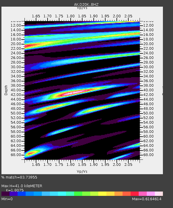
| Estimated Moho Depth: |
41.0 km |
| Estimated Crust Vp/Vs: |
1.81 |
| Assumed Crust Vp: |
6.221 km/s |
| Estimated Crust Vs: |
3.442 km/s |
| Estimated Crust Poisson's Ratio: |
0.28 |
|
| Radial Match: |
83.73955 % |
| Radial Bump: |
400 |
| Transverse Match: |
71.98189 % |
| Transverse Bump: |
400 |
| SOD ConfigId: |
28208852 |
| Insert Time: |
2022-07-15 21:34:35.364 +0000 |
| GWidth: |
2.5 |
| Max Bumps: |
400 |
| Tol: |
0.001 |
|

Signal To Noise
| Channel | StoN | STA | LTA |
| AK:D20K: :BHZ:20220701T21:43:55.559971Z | 19.401379 | 1.6048461E-6 | 8.271815E-8 |
| AK:D20K: :BHN:20220701T21:43:55.559971Z | 4.8959427 | 2.0220094E-7 | 4.1299693E-8 |
| AK:D20K: :BHE:20220701T21:43:55.559971Z | 4.449658 | 2.6736038E-7 | 6.00856E-8 |
| Arrivals |
| Ps | 5.5 SECOND |
| PpPs | 18 SECOND |
| PsPs/PpSs | 24 SECOND |


