You are here: Home > Network List > US - United States National Seismic Network Stations List
> Station HAWA Hanford, Washington, USA > Earthquake Result Viewer
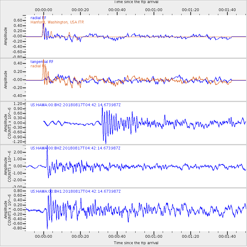
HAWA Hanford, Washington, USA - Earthquake Result Viewer
*The percent match for this event was below the threshold and hence no stack was calculated.
| Earthquake location: |
Andreanof Islands, Aleutian Is. |
| Earthquake latitude/longitude: |
51.3/-178.2 |
| Earthquake time(UTC): |
2018/08/17 (229) 04:35:29 GMT |
| Earthquake Depth: |
25 km |
| Earthquake Magnitude: |
5.8 Ml |
| Earthquake Catalog/Contributor: |
NEIC PDE/us |
|
| Network: |
US United States National Seismic Network |
| Station: |
HAWA Hanford, Washington, USA |
| Lat/Lon: |
46.39 N/119.53 W |
| Elevation: |
364 m |
|
| Distance: |
38.0 deg |
| Az: |
73.75 deg |
| Baz: |
299.529 deg |
| Ray Param: |
$rayparam |
*The percent match for this event was below the threshold and hence was not used in the summary stack. |
|
| Radial Match: |
70.82995 % |
| Radial Bump: |
400 |
| Transverse Match: |
58.253838 % |
| Transverse Bump: |
400 |
| SOD ConfigId: |
2825771 |
| Insert Time: |
2018-08-31 04:50:54.218 +0000 |
| GWidth: |
2.5 |
| Max Bumps: |
400 |
| Tol: |
0.001 |
|
Signal To Noise
| Channel | StoN | STA | LTA |
| US:HAWA:00:BHZ:20180817T04:42:14.673987Z | 9.955151 | 9.1315223E-7 | 9.1726605E-8 |
| US:HAWA:00:BH1:20180817T04:42:14.673987Z | 5.2737474 | 3.608175E-7 | 6.841767E-8 |
| US:HAWA:00:BH2:20180817T04:42:14.673987Z | 7.595637 | 5.482568E-7 | 7.218049E-8 |
| Arrivals |
| Ps | |
| PpPs | |
| PsPs/PpSs | |


