You are here: Home > Network List > DK - Danish Seismological Network Stations List
> Station ILULI Ilulissat, Greenland > Earthquake Result Viewer
ILULI Ilulissat, Greenland - Earthquake Result Viewer
| Earthquake location: |
Southern Iran |
| Earthquake latitude/longitude: |
26.9/55.2 |
| Earthquake time(UTC): |
2022/07/01 (182) 21:32:07 GMT |
| Earthquake Depth: |
10 km |
| Earthquake Magnitude: |
6.1 mww |
| Earthquake Catalog/Contributor: |
NEIC PDE/us |
|
| Network: |
DK Danish Seismological Network |
| Station: |
ILULI Ilulissat, Greenland |
| Lat/Lon: |
69.21 N/51.10 W |
| Elevation: |
54 m |
|
| Distance: |
70.6 deg |
| Az: |
338.709 deg |
| Baz: |
65.226 deg |
| Ray Param: |
0.054856528 |
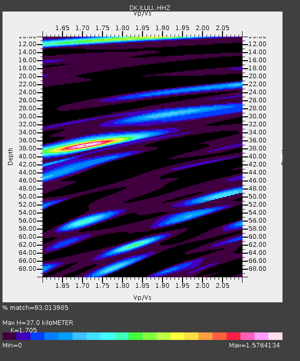
| Estimated Moho Depth: |
37.0 km |
| Estimated Crust Vp/Vs: |
1.71 |
| Assumed Crust Vp: |
6.459 km/s |
| Estimated Crust Vs: |
3.789 km/s |
| Estimated Crust Poisson's Ratio: |
0.24 |
|
| Radial Match: |
93.013985 % |
| Radial Bump: |
400 |
| Transverse Match: |
80.15518 % |
| Transverse Bump: |
400 |
| SOD ConfigId: |
28208852 |
| Insert Time: |
2022-07-15 21:43:44.660 +0000 |
| GWidth: |
2.5 |
| Max Bumps: |
400 |
| Tol: |
0.001 |
|

Signal To Noise
| Channel | StoN | STA | LTA |
| DK:ILULI: :HHZ:20220701T21:42:52.36002Z | 26.462236 | 1.9854622E-6 | 7.503002E-8 |
| DK:ILULI: :HHN:20220701T21:42:52.36002Z | 4.7900124 | 3.0225877E-7 | 6.310187E-8 |
| DK:ILULI: :HHE:20220701T21:42:52.36002Z | 12.516631 | 8.168501E-7 | 6.5261176E-8 |
| Arrivals |
| Ps | 4.2 SECOND |
| PpPs | 15 SECOND |
| PsPs/PpSs | 19 SECOND |


