You are here: Home > Network List > US - United States National Seismic Network Stations List
> Station MNTX Cornudas Mountains, Texas, USA > Earthquake Result Viewer
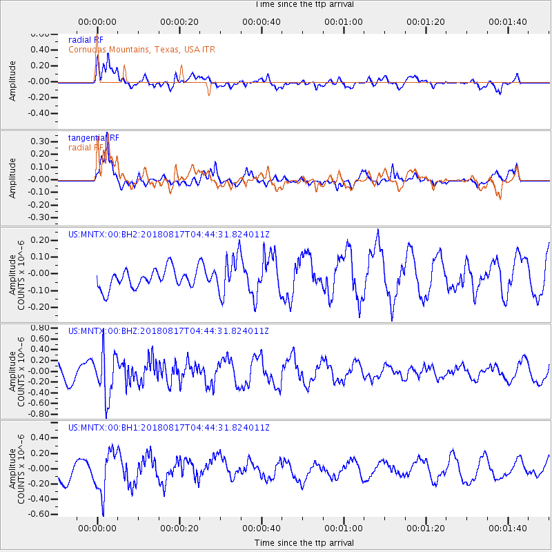
MNTX Cornudas Mountains, Texas, USA - Earthquake Result Viewer
*The percent match for this event was below the threshold and hence no stack was calculated.
| Earthquake location: |
Andreanof Islands, Aleutian Is. |
| Earthquake latitude/longitude: |
51.3/-178.2 |
| Earthquake time(UTC): |
2018/08/17 (229) 04:35:29 GMT |
| Earthquake Depth: |
25 km |
| Earthquake Magnitude: |
5.8 Ml |
| Earthquake Catalog/Contributor: |
NEIC PDE/us |
|
| Network: |
US United States National Seismic Network |
| Station: |
MNTX Cornudas Mountains, Texas, USA |
| Lat/Lon: |
31.70 N/105.38 W |
| Elevation: |
404 m |
|
| Distance: |
55.6 deg |
| Az: |
80.815 deg |
| Baz: |
313.407 deg |
| Ray Param: |
$rayparam |
*The percent match for this event was below the threshold and hence was not used in the summary stack. |
|
| Radial Match: |
79.1176 % |
| Radial Bump: |
400 |
| Transverse Match: |
78.64249 % |
| Transverse Bump: |
376 |
| SOD ConfigId: |
2825771 |
| Insert Time: |
2018-08-31 04:52:15.534 +0000 |
| GWidth: |
2.5 |
| Max Bumps: |
400 |
| Tol: |
0.001 |
|
Signal To Noise
| Channel | StoN | STA | LTA |
| US:MNTX:00:BHZ:20180817T04:44:31.824011Z | 2.6702116 | 4.1712013E-7 | 1.562124E-7 |
| US:MNTX:00:BH1:20180817T04:44:31.824011Z | 1.7358633 | 2.758246E-7 | 1.5889763E-7 |
| US:MNTX:00:BH2:20180817T04:44:31.824011Z | 2.1164656 | 1.18477054E-7 | 5.597873E-8 |
| Arrivals |
| Ps | |
| PpPs | |
| PsPs/PpSs | |


