You are here: Home > Network List > IN - National Seismic Network of India Stations List
> Station PBA Port Blair, Andaman and Nicobar Islands, India > Earthquake Result Viewer
PBA Port Blair, Andaman and Nicobar Islands, India - Earthquake Result Viewer
| Earthquake location: |
Southern Iran |
| Earthquake latitude/longitude: |
26.9/55.2 |
| Earthquake time(UTC): |
2022/07/01 (182) 21:32:07 GMT |
| Earthquake Depth: |
10 km |
| Earthquake Magnitude: |
6.1 mww |
| Earthquake Catalog/Contributor: |
NEIC PDE/us |
|
| Network: |
IN National Seismic Network of India |
| Station: |
PBA Port Blair, Andaman and Nicobar Islands, India |
| Lat/Lon: |
11.66 N/92.74 E |
| Elevation: |
79 m |
|
| Distance: |
38.4 deg |
| Az: |
105.992 deg |
| Baz: |
298.839 deg |
| Ray Param: |
0.07563114 |
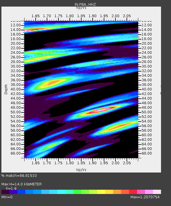
| Estimated Moho Depth: |
14.0 km |
| Estimated Crust Vp/Vs: |
1.60 |
| Assumed Crust Vp: |
6.32 km/s |
| Estimated Crust Vs: |
3.95 km/s |
| Estimated Crust Poisson's Ratio: |
0.18 |
|
| Radial Match: |
86.81533 % |
| Radial Bump: |
400 |
| Transverse Match: |
84.101845 % |
| Transverse Bump: |
400 |
| SOD ConfigId: |
28208852 |
| Insert Time: |
2022-07-15 21:46:04.403 +0000 |
| GWidth: |
2.5 |
| Max Bumps: |
400 |
| Tol: |
0.001 |
|

Signal To Noise
| Channel | StoN | STA | LTA |
| IN:PBA: :HHZ:20220701T21:38:58.250004Z | 13.268927 | 5.1153334E-6 | 3.855122E-7 |
| IN:PBA: :HHN:20220701T21:38:58.250004Z | 5.624394 | 1.8118109E-6 | 3.221344E-7 |
| IN:PBA: :HHE:20220701T21:38:58.250004Z | 2.676538 | 1.293524E-6 | 4.832825E-7 |
| Arrivals |
| Ps | 1.4 SECOND |
| PpPs | 5.3 SECOND |
| PsPs/PpSs | 6.8 SECOND |


