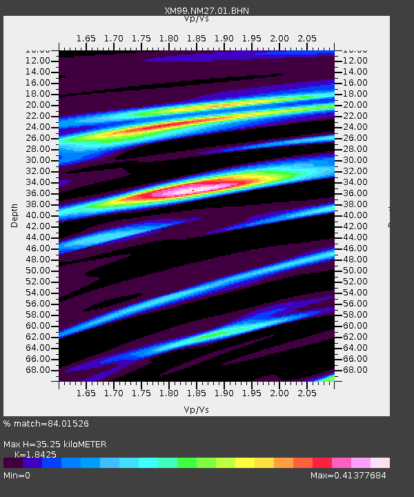
NM27 NewMexico27 - Earthquake Result Viewer

Earthquake location: Vanuatu Islands Region
Earthquake latitude/longitude: -19.5/173.8
Earthquake time(UTC): 2000/02/25 (056) 01:43:58 GMT
Earthquake Depth: 33 km
Earthquake Magnitude: 6.1 MB, 7.1 MS, 7.1 MW, 7.0 MW
Earthquake Catalog/Contributor: WHDF/NEIC
Network: XM Rio Grande Seismic Transect
Station: NM27 NewMexico27
Lat/Lon: 34.39 N/106.52 W
Elevation: 1870 m
Distance: 92.7 deg
Az: 54.535 deg
Baz: 248.26 deg
Ray Param: 0.041399572
Estimated Moho Depth: 35.25 km
Estimated Crust Vp/Vs: 1.84
Assumed Crust Vp: 6.502 km/s
Estimated Crust Vs: 3.529 km/s
Estimated Crust Poisson's Ratio: 0.29
Radial Match: 84.01526 %
Radial Bump: 273
Transverse Match: 62.387302 %
Transverse Bump: 400
SOD ConfigId: 16820
Insert Time: 2010-02-26 17:31:38.502 +0000
GWidth: 2.5
Max Bumps: 400
Tol: 0.001

Signal To Noise

ChannelStoNSTALTA
XM:NM27:01:BHN:20000225T01:56:35.905015Z1.84674992.797358E-71.5147465E-7
XM:NM27:01:BHE:20000225T01:56:35.905015Z2.07394862.0839086E-71.00480236E-7
XM:NM27:01:BHZ:20000225T01:56:35.905015Z1.16561261.5474174E-71.3275573E-7
Arrivals
Ps4.7 SECOND
PpPs15 SECOND
PsPs/PpSs20 SECOND