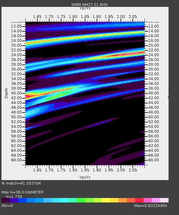
NM27 NewMexico27 - Earthquake Result Viewer

Earthquake location: Panama-Colombia Border Region
Earthquake latitude/longitude: 7.0/-77.8
Earthquake time(UTC): 2000/11/08 (313) 06:59:58 GMT
Earthquake Depth: 17 km
Earthquake Magnitude: 6.0 MB, 6.4 MS, 6.5 MW, 6.2 ML
Earthquake Catalog/Contributor: WHDF/NEIC
Network: XM Rio Grande Seismic Transect
Station: NM27 NewMexico27
Lat/Lon: 34.39 N/106.52 W
Elevation: 1870 m
Distance: 38.0 deg
Az: 319.785 deg
Baz: 129.204 deg
Ray Param: 0.075824454
Estimated Moho Depth: 39.0 km
Estimated Crust Vp/Vs: 1.74
Assumed Crust Vp: 6.502 km/s
Estimated Crust Vs: 3.747 km/s
Estimated Crust Poisson's Ratio: 0.25
Radial Match: 91.053764 %
Radial Bump: 257
Transverse Match: 55.754704 %
Transverse Bump: 400
SOD ConfigId: 3744
Insert Time: 2010-02-26 17:31:40.156 +0000
GWidth: 2.5
Max Bumps: 400
Tol: 0.001

Signal To Noise

ChannelStoNSTALTA
XM:NM27:01:BHN:20001108T07:06:44.715988Z1.62504541.5058927E-79.2667726E-8
XM:NM27:01:BHE:20001108T07:06:44.715988Z1.01400361.3846685E-71.3655459E-7
XM:NM27:01:BHZ:20001108T07:06:44.715988Z3.07825282.9439641E-79.563751E-8
Arrivals
Ps4.8 SECOND
PpPs15 SECOND
PsPs/PpSs20 SECOND