You are here: Home > Network List > G - GEOSCOPE Stations List
> Station IVI Ivittuut, Greenland > Earthquake Result Viewer
IVI Ivittuut, Greenland - Earthquake Result Viewer
| Earthquake location: |
Southern Iran |
| Earthquake latitude/longitude: |
26.9/55.2 |
| Earthquake time(UTC): |
2022/07/01 (182) 23:24:14 GMT |
| Earthquake Depth: |
10 km |
| Earthquake Magnitude: |
6.1 mb |
| Earthquake Catalog/Contributor: |
NEIC PDE/us |
|
| Network: |
G GEOSCOPE |
| Station: |
IVI Ivittuut, Greenland |
| Lat/Lon: |
61.21 N/48.17 W |
| Elevation: |
15 m |
|
| Distance: |
72.9 deg |
| Az: |
330.477 deg |
| Baz: |
65.328 deg |
| Ray Param: |
0.05336721 |
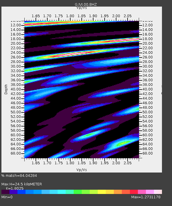
| Estimated Moho Depth: |
24.5 km |
| Estimated Crust Vp/Vs: |
1.80 |
| Assumed Crust Vp: |
6.472 km/s |
| Estimated Crust Vs: |
3.59 km/s |
| Estimated Crust Poisson's Ratio: |
0.28 |
|
| Radial Match: |
84.04284 % |
| Radial Bump: |
400 |
| Transverse Match: |
73.73733 % |
| Transverse Bump: |
400 |
| SOD ConfigId: |
28208852 |
| Insert Time: |
2022-07-15 23:35:14.943 +0000 |
| GWidth: |
2.5 |
| Max Bumps: |
400 |
| Tol: |
0.001 |
|
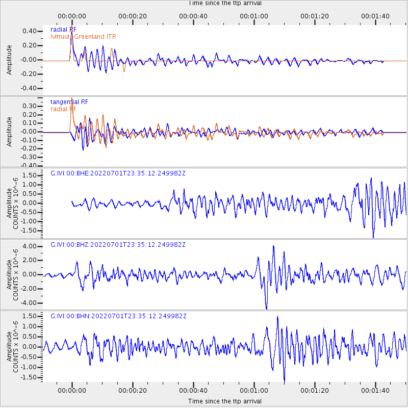
Signal To Noise
| Channel | StoN | STA | LTA |
| G:IVI:00:BHZ:20220701T23:35:12.249982Z | 6.143751 | 1.0063347E-6 | 1.637981E-7 |
| G:IVI:00:BHN:20220701T23:35:12.249982Z | 1.3995421 | 2.7386122E-7 | 1.9567916E-7 |
| G:IVI:00:BHE:20220701T23:35:12.249982Z | 2.1584444 | 2.7283446E-7 | 1.2640328E-7 |
| Arrivals |
| Ps | 3.1 SECOND |
| PpPs | 10 SECOND |
| PsPs/PpSs | 13 SECOND |


