You are here: Home > Network List > G - GEOSCOPE Stations List
> Station TAM Tamanrasset, Algeria > Earthquake Result Viewer
TAM Tamanrasset, Algeria - Earthquake Result Viewer
| Earthquake location: |
Southern Iran |
| Earthquake latitude/longitude: |
26.9/55.2 |
| Earthquake time(UTC): |
2022/07/01 (182) 23:24:14 GMT |
| Earthquake Depth: |
10 km |
| Earthquake Magnitude: |
6.1 mb |
| Earthquake Catalog/Contributor: |
NEIC PDE/us |
|
| Network: |
G GEOSCOPE |
| Station: |
TAM Tamanrasset, Algeria |
| Lat/Lon: |
22.79 N/5.53 E |
| Elevation: |
1377 m |
|
| Distance: |
45.0 deg |
| Az: |
276.081 deg |
| Baz: |
74.156 deg |
| Ray Param: |
0.07154072 |
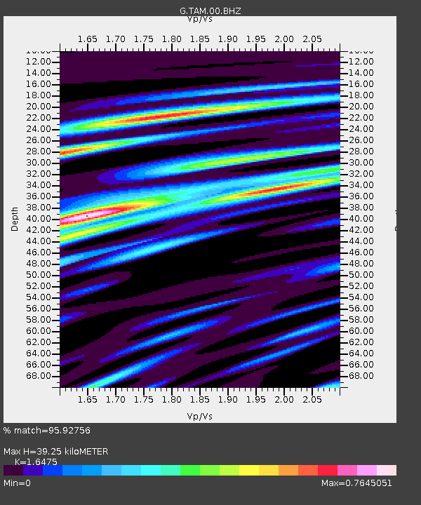
| Estimated Moho Depth: |
39.25 km |
| Estimated Crust Vp/Vs: |
1.65 |
| Assumed Crust Vp: |
6.61 km/s |
| Estimated Crust Vs: |
4.012 km/s |
| Estimated Crust Poisson's Ratio: |
0.21 |
|
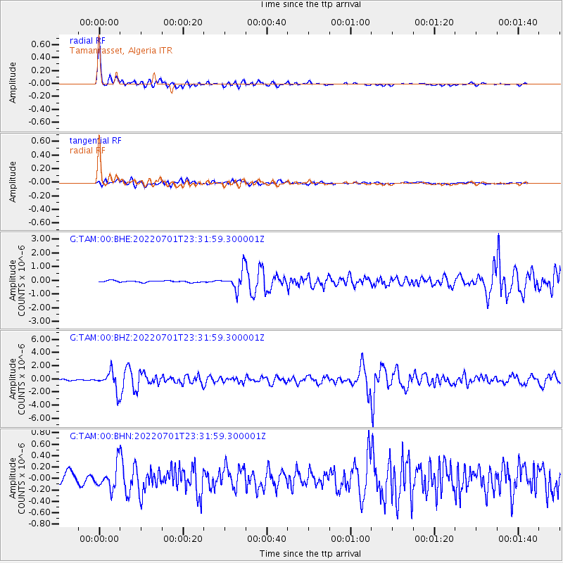
| Radial Match: |
95.92756 % |
| Radial Bump: |
394 |
| Transverse Match: |
78.308556 % |
| Transverse Bump: |
400 |
| SOD ConfigId: |
28208852 |
| Insert Time: |
2022-07-15 23:35:18.669 +0000 |
| GWidth: |
2.5 |
| Max Bumps: |
400 |
| Tol: |
0.001 |
|
Signal To Noise
| Channel | StoN | STA | LTA |
| G:TAM:00:BHZ:20220701T23:31:59.300001Z | 19.73178 | 1.485343E-6 | 7.527669E-8 |
| G:TAM:00:BHN:20220701T23:31:59.300001Z | 3.2889159 | 2.1566967E-7 | 6.5574696E-8 |
| G:TAM:00:BHE:20220701T23:31:59.300001Z | 12.449282 | 7.383794E-7 | 5.9311006E-8 |
| Arrivals |
| Ps | 4.1 SECOND |
| PpPs | 15 SECOND |
| PsPs/PpSs | 19 SECOND |


