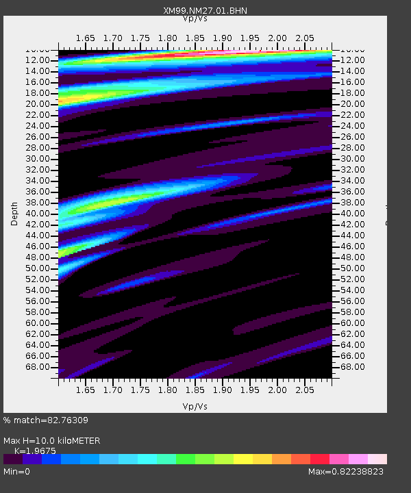
NM27 NewMexico27 - Earthquake Result Viewer

Earthquake location: Galapagos Islands Region
Earthquake latitude/longitude: 1.8/-90.6
Earthquake time(UTC): 2000/10/21 (295) 15:52:47 GMT
Earthquake Depth: 10 km
Earthquake Magnitude: 5.2 MB, 5.5 MS, 6.0 MW, 5.9 MW
Earthquake Catalog/Contributor: WHDF/NEIC
Network: XM Rio Grande Seismic Transect
Station: NM27 NewMexico27
Lat/Lon: 34.39 N/106.52 W
Elevation: 1870 m
Distance: 35.6 deg
Az: 337.062 deg
Baz: 151.899 deg
Ray Param: 0.077113524
Estimated Moho Depth: 10.0 km
Estimated Crust Vp/Vs: 1.97
Assumed Crust Vp: 6.502 km/s
Estimated Crust Vs: 3.304 km/s
Estimated Crust Poisson's Ratio: 0.33
Radial Match: 82.76309 %
Radial Bump: 352
Transverse Match: 48.88747 %
Transverse Bump: 400
SOD ConfigId: 27569
Insert Time: 2010-02-26 17:31:40.993 +0000
GWidth: 2.5
Max Bumps: 400
Tol: 0.001

Signal To Noise

ChannelStoNSTALTA
XM:NM27:01:BHN:20001021T15:59:14.367009Z2.29575421.751717E-77.630247E-8
XM:NM27:01:BHE:20001021T15:59:14.367009Z0.7498927.549761E-81.0067797E-7
XM:NM27:01:BHZ:20001021T15:59:14.367009Z2.38403732.2563225E-79.464292E-8
Arrivals
Ps1.6 SECOND
PpPs4.3 SECOND
PsPs/PpSs5.9 SECOND