You are here: Home > Network List > AK - Alaska Regional Network Stations List
> Station E18K Tukpahlearik Creek, AK, USA > Earthquake Result Viewer
E18K Tukpahlearik Creek, AK, USA - Earthquake Result Viewer
| Earthquake location: |
Southern Iran |
| Earthquake latitude/longitude: |
26.9/55.3 |
| Earthquake time(UTC): |
2022/07/01 (182) 23:25:15 GMT |
| Earthquake Depth: |
10 km |
| Earthquake Magnitude: |
6.0 Mwb |
| Earthquake Catalog/Contributor: |
NEIC PDE/us |
|
| Network: |
AK Alaska Regional Network |
| Station: |
E18K Tukpahlearik Creek, AK, USA |
| Lat/Lon: |
67.42 N/160.60 W |
| Elevation: |
297 m |
|
| Distance: |
82.2 deg |
| Az: |
13.207 deg |
| Baz: |
328.102 deg |
| Ray Param: |
0.047047324 |
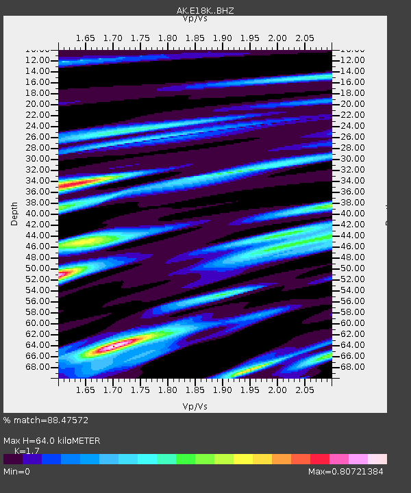
| Estimated Moho Depth: |
64.0 km |
| Estimated Crust Vp/Vs: |
1.70 |
| Assumed Crust Vp: |
6.276 km/s |
| Estimated Crust Vs: |
3.692 km/s |
| Estimated Crust Poisson's Ratio: |
0.24 |
|
| Radial Match: |
88.47572 % |
| Radial Bump: |
400 |
| Transverse Match: |
79.36663 % |
| Transverse Bump: |
400 |
| SOD ConfigId: |
28208852 |
| Insert Time: |
2022-07-15 23:43:05.779 +0000 |
| GWidth: |
2.5 |
| Max Bumps: |
400 |
| Tol: |
0.001 |
|

Signal To Noise
| Channel | StoN | STA | LTA |
| AK:E18K: :BHZ:20220701T23:37:04.820Z | 6.354238 | 1.4916403E-6 | 2.3474732E-7 |
| AK:E18K: :BHN:20220701T23:37:04.820Z | 3.033262 | 3.8545653E-7 | 1.2707656E-7 |
| AK:E18K: :BHE:20220701T23:37:04.820Z | 2.1890016 | 3.3392593E-7 | 1.5254713E-7 |
| Arrivals |
| Ps | 7.3 SECOND |
| PpPs | 27 SECOND |
| PsPs/PpSs | 34 SECOND |


