You are here: Home > Network List > G - GEOSCOPE Stations List
> Station INU Inuyama, Japan > Earthquake Result Viewer
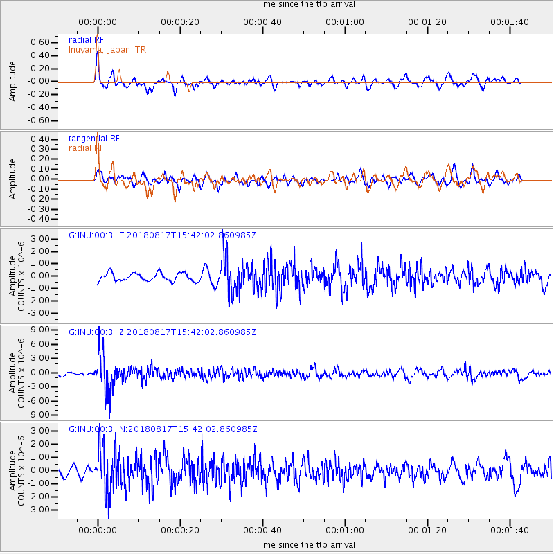
INU Inuyama, Japan - Earthquake Result Viewer
*The percent match for this event was below the threshold and hence no stack was calculated.
| Earthquake location: |
Flores Sea |
| Earthquake latitude/longitude: |
-7.4/119.8 |
| Earthquake time(UTC): |
2018/08/17 (229) 15:35:02 GMT |
| Earthquake Depth: |
539 km |
| Earthquake Magnitude: |
6.5 Mww |
| Earthquake Catalog/Contributor: |
NEIC PDE/us |
|
| Network: |
G GEOSCOPE |
| Station: |
INU Inuyama, Japan |
| Lat/Lon: |
35.35 N/137.03 E |
| Elevation: |
132 m |
|
| Distance: |
45.5 deg |
| Az: |
19.813 deg |
| Baz: |
204.282 deg |
| Ray Param: |
$rayparam |
*The percent match for this event was below the threshold and hence was not used in the summary stack. |
|
| Radial Match: |
63.224194 % |
| Radial Bump: |
400 |
| Transverse Match: |
39.616863 % |
| Transverse Bump: |
400 |
| SOD ConfigId: |
2825771 |
| Insert Time: |
2018-08-31 15:38:21.811 +0000 |
| GWidth: |
2.5 |
| Max Bumps: |
400 |
| Tol: |
0.001 |
|
Signal To Noise
| Channel | StoN | STA | LTA |
| G:INU:00:BHZ:20180817T15:42:02.860985Z | 10.553233 | 3.728359E-6 | 3.5329072E-7 |
| G:INU:00:BHN:20180817T15:42:02.860985Z | 3.22373 | 1.6502192E-6 | 5.118975E-7 |
| G:INU:00:BHE:20180817T15:42:02.860985Z | 4.8992295 | 1.5752466E-6 | 3.2152946E-7 |
| Arrivals |
| Ps | |
| PpPs | |
| PsPs/PpSs | |


