You are here: Home > Network List > IU - Global Seismograph Network (GSN - IRIS/USGS) Stations List
> Station KMBO Kilima Mbogo, Kenya > Earthquake Result Viewer
KMBO Kilima Mbogo, Kenya - Earthquake Result Viewer

| Earthquake location: |
Flores Sea |
| Earthquake latitude/longitude: |
-7.4/119.8 |
| Earthquake time(UTC): |
2018/08/17 (229) 15:35:02 GMT |
| Earthquake Depth: |
539 km |
| Earthquake Magnitude: |
6.5 Mww |
| Earthquake Catalog/Contributor: |
NEIC PDE/us |
|
| Network: |
IU Global Seismograph Network (GSN - IRIS/USGS) |
| Station: |
KMBO Kilima Mbogo, Kenya |
| Lat/Lon: |
1.13 S/37.25 E |
| Elevation: |
1950 m |
|
| Distance: |
82.5 deg |
| Az: |
269.838 deg |
| Baz: |
97.281 deg |
| Ray Param: |
0.04528021 |
| Estimated Moho Depth: |
46.0 km |
| Estimated Crust Vp/Vs: |
1.69 |
| Assumed Crust Vp: |
6.601 km/s |
| Estimated Crust Vs: |
3.906 km/s |
| Estimated Crust Poisson's Ratio: |
0.23 |
|
| Radial Match: |
94.11699 % |
| Radial Bump: |
263 |
| Transverse Match: |
83.58901 % |
| Transverse Bump: |
400 |
| SOD ConfigId: |
2825771 |
| Insert Time: |
2018-08-31 15:39:16.109 +0000 |
| GWidth: |
2.5 |
| Max Bumps: |
400 |
| Tol: |
0.001 |
|
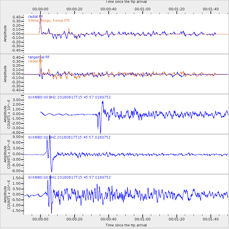
Signal To Noise
| Channel | StoN | STA | LTA |
| IU:KMBO:00:BHZ:20180817T15:45:57.018975Z | 19.492382 | 2.0878485E-6 | 1.0711099E-7 |
| IU:KMBO:00:BH1:20180817T15:45:57.018975Z | 2.9847422 | 3.4524112E-7 | 1.1566865E-7 |
| IU:KMBO:00:BH2:20180817T15:45:57.018975Z | 4.886298 | 6.9883635E-7 | 1.4301958E-7 |
| Arrivals |
| Ps | 4.9 SECOND |
| PpPs | 18 SECOND |
| PsPs/PpSs | 23 SECOND |


