You are here: Home > Network List > ND - New CaleDonia Broadband Seismic Network Stations List
> Station MARNC Mare, Loyalty islands, New Caledonia > Earthquake Result Viewer
MARNC Mare, Loyalty islands, New Caledonia - Earthquake Result Viewer
| Earthquake location: |
Flores Sea |
| Earthquake latitude/longitude: |
-7.4/119.8 |
| Earthquake time(UTC): |
2018/08/17 (229) 15:35:02 GMT |
| Earthquake Depth: |
539 km |
| Earthquake Magnitude: |
6.5 Mww |
| Earthquake Catalog/Contributor: |
NEIC PDE/us |
|
| Network: |
ND New CaleDonia Broadband Seismic Network |
| Station: |
MARNC Mare, Loyalty islands, New Caledonia |
| Lat/Lon: |
21.48 S/168.03 E |
| Elevation: |
44 m |
|
| Distance: |
48.5 deg |
| Az: |
112.066 deg |
| Baz: |
279.309 deg |
| Ray Param: |
0.06681408 |
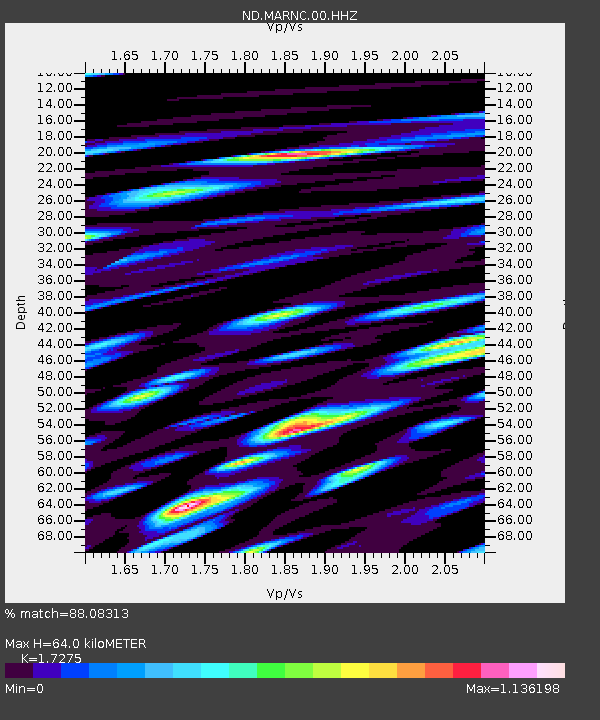
| Estimated Moho Depth: |
64.0 km |
| Estimated Crust Vp/Vs: |
1.73 |
| Assumed Crust Vp: |
4.082 km/s |
| Estimated Crust Vs: |
2.363 km/s |
| Estimated Crust Poisson's Ratio: |
0.25 |
|
| Radial Match: |
88.08313 % |
| Radial Bump: |
400 |
| Transverse Match: |
80.14724 % |
| Transverse Bump: |
400 |
| SOD ConfigId: |
2825771 |
| Insert Time: |
2018-08-31 15:40:04.773 +0000 |
| GWidth: |
2.5 |
| Max Bumps: |
400 |
| Tol: |
0.001 |
|
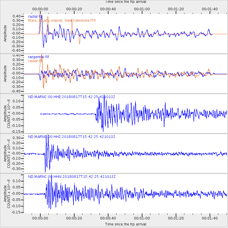
Signal To Noise
| Channel | StoN | STA | LTA |
| ND:MARNC:00:HHZ:20180817T15:42:25.421013Z | 21.721136 | 1.3769497E-7 | 6.339216E-9 |
| ND:MARNC:00:HHN:20180817T15:42:25.421013Z | 17.591389 | 3.5029245E-8 | 1.991272E-9 |
| ND:MARNC:00:HHE:20180817T15:42:25.421013Z | 17.704409 | 3.356343E-8 | 1.8957669E-9 |
| Arrivals |
| Ps | 12 SECOND |
| PpPs | 42 SECOND |
| PsPs/PpSs | 53 SECOND |


