You are here: Home > Network List > XM99 - Rio Grande Seismic Transect Stations List
> Station NM27 NewMexico27 > Earthquake Result Viewer
NM27 NewMexico27 - Earthquake Result Viewer
| Earthquake location: |
Tonga Islands |
| Earthquake latitude/longitude: |
-15.9/-173.7 |
| Earthquake time(UTC): |
2000/09/11 (255) 17:17:53 GMT |
| Earthquake Depth: |
115 km |
| Earthquake Magnitude: |
6.0 MB, 6.3 MW, 6.3 MW |
| Earthquake Catalog/Contributor: |
WHDF/NEIC |
|
| Network: |
XM Rio Grande Seismic Transect |
| Station: |
NM27 NewMexico27 |
| Lat/Lon: |
34.39 N/106.52 W |
| Elevation: |
1870 m |
|
| Distance: |
81.0 deg |
| Az: |
50.503 deg |
| Baz: |
243.885 deg |
| Ray Param: |
0.04761062 |
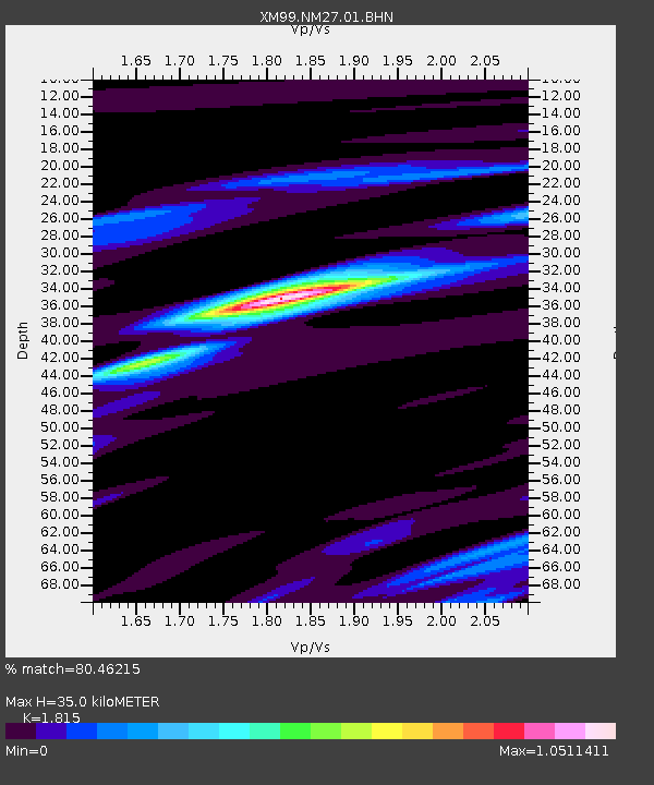
| Estimated Moho Depth: |
35.0 km |
| Estimated Crust Vp/Vs: |
1.82 |
| Assumed Crust Vp: |
6.502 km/s |
| Estimated Crust Vs: |
3.582 km/s |
| Estimated Crust Poisson's Ratio: |
0.28 |
|
| Radial Match: |
80.46215 % |
| Radial Bump: |
400 |
| Transverse Match: |
57.79444 % |
| Transverse Bump: |
400 |
| SOD ConfigId: |
16820 |
| Insert Time: |
2010-02-26 17:31:51.627 +0000 |
| GWidth: |
2.5 |
| Max Bumps: |
400 |
| Tol: |
0.001 |
|

Signal To Noise
| Channel | StoN | STA | LTA |
| XM:NM27:01:BHN:20000911T17:29:24.417029Z | 1.4798914 | 3.9424603E-7 | 2.66402E-7 |
| XM:NM27:01:BHE:20000911T17:29:24.417029Z | 2.8443208 | 6.822482E-7 | 2.398633E-7 |
| XM:NM27:01:BHZ:20000911T17:29:24.417029Z | 8.96587 | 2.0951193E-6 | 2.336772E-7 |
| Arrivals |
| Ps | 4.5 SECOND |
| PpPs | 15 SECOND |
| PsPs/PpSs | 19 SECOND |


