You are here: Home > Network List > TW - Broadband Array in Taiwan for Seismology Stations List
> Station SSLB SUANG-LONG > Earthquake Result Viewer
SSLB SUANG-LONG - Earthquake Result Viewer
| Earthquake location: |
Banda Sea |
| Earthquake latitude/longitude: |
-6.5/129.9 |
| Earthquake time(UTC): |
2005/03/02 (061) 10:42:12 GMT |
| Earthquake Depth: |
202 km |
| Earthquake Magnitude: |
7.0 MB, 7.1 MW, 7.1 MW |
| Earthquake Catalog/Contributor: |
WHDF/NEIC |
|
| Network: |
TW Broadband Array in Taiwan for Seismology |
| Station: |
SSLB SUANG-LONG |
| Lat/Lon: |
23.79 N/120.95 E |
| Elevation: |
450 m |
|
| Distance: |
31.4 deg |
| Az: |
344.064 deg |
| Baz: |
162.673 deg |
| Ray Param: |
0.078494586 |
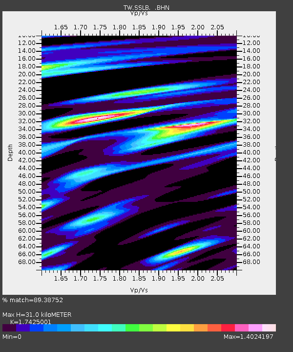
| Estimated Moho Depth: |
31.0 km |
| Estimated Crust Vp/Vs: |
1.74 |
| Assumed Crust Vp: |
6.461 km/s |
| Estimated Crust Vs: |
3.708 km/s |
| Estimated Crust Poisson's Ratio: |
0.25 |
|
| Radial Match: |
89.38752 % |
| Radial Bump: |
400 |
| Transverse Match: |
80.073524 % |
| Transverse Bump: |
400 |
| SOD ConfigId: |
2455 |
| Insert Time: |
2010-03-09 21:50:59.152 +0000 |
| GWidth: |
2.5 |
| Max Bumps: |
400 |
| Tol: |
0.001 |
|

Signal To Noise
| Channel | StoN | STA | LTA |
| TW:SSLB: :BHN:20050302T10:47:43.722004Z | 23.437216 | 5.5288333E-6 | 2.3589976E-7 |
| TW:SSLB: :BHE:20050302T10:47:43.722004Z | 10.529953 | 3.7410975E-6 | 3.552815E-7 |
| TW:SSLB: :BHZ:20050302T10:47:43.722004Z | 20.672964 | 8.362129E-6 | 4.044959E-7 |
| Arrivals |
| Ps | 3.9 SECOND |
| PpPs | 12 SECOND |
| PsPs/PpSs | 16 SECOND |


