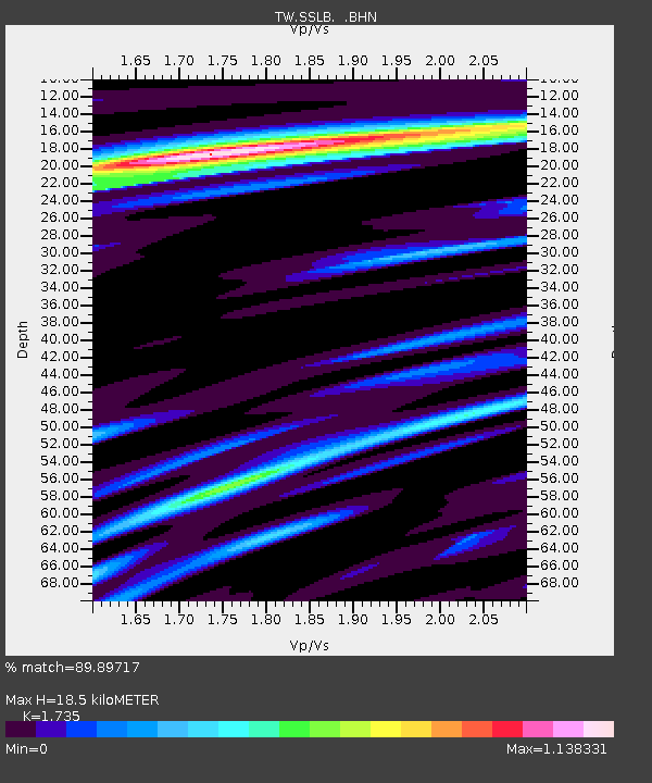
SSLB SUANG-LONG - Earthquake Result Viewer

Earthquake location: Southwest Of Sumatra, Indonesia
Earthquake latitude/longitude: -0.2/97.7
Earthquake time(UTC): 2005/04/08 (098) 05:48:37 GMT
Earthquake Depth: 21 km
Earthquake Magnitude: 5.7 MB, 6.3 MS, 6.1 MW, 6.1 MW
Earthquake Catalog/Contributor: WHDF/NEIC
Network: TW Broadband Array in Taiwan for Seismology
Station: SSLB SUANG-LONG
Lat/Lon: 23.79 N/120.95 E
Elevation: 450 m
Distance: 32.8 deg
Az: 41.784 deg
Baz: 226.668 deg
Ray Param: 0.07846506
Estimated Moho Depth: 18.5 km
Estimated Crust Vp/Vs: 1.74
Assumed Crust Vp: 6.461 km/s
Estimated Crust Vs: 3.724 km/s
Estimated Crust Poisson's Ratio: 0.25
Radial Match: 89.89717 %
Radial Bump: 378
Transverse Match: 80.2455 %
Transverse Bump: 400
SOD ConfigId: 2459
Insert Time: 2010-03-09 21:51:07.402 +0000
GWidth: 2.5
Max Bumps: 400
Tol: 0.001

Signal To Noise

ChannelStoNSTALTA
TW:SSLB: :BHN:20050408T05:54:39.270991Z1.80044731.4171276E-77.870975E-8
TW:SSLB: :BHE:20050408T05:54:39.270991Z1.26976111.6157806E-71.2725076E-7
TW:SSLB: :BHZ:20050408T05:54:39.270991Z3.30909183.3524304E-71.0130969E-7
Arrivals
Ps2.3 SECOND
PpPs7.2 SECOND
PsPs/PpSs9.5 SECOND