You are here: Home > Network List > PF - Volcanologic Network of Piton de Fournaise-OVPF Stations List
> Station GPS Grandes Pentes Sud > Earthquake Result Viewer
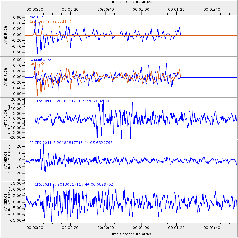
GPS Grandes Pentes Sud - Earthquake Result Viewer
*The percent match for this event was below the threshold and hence no stack was calculated.
| Earthquake location: |
Flores Sea |
| Earthquake latitude/longitude: |
-7.4/119.8 |
| Earthquake time(UTC): |
2018/08/17 (229) 15:35:02 GMT |
| Earthquake Depth: |
539 km |
| Earthquake Magnitude: |
6.5 Mww |
| Earthquake Catalog/Contributor: |
NEIC PDE/us |
|
| Network: |
PF Volcanologic Network of Piton de Fournaise-OVPF |
| Station: |
GPS Grandes Pentes Sud |
| Lat/Lon: |
21.27 S/55.76 E |
| Elevation: |
1004 m |
|
| Distance: |
63.2 deg |
| Az: |
249.997 deg |
| Baz: |
87.631 deg |
| Ray Param: |
$rayparam |
*The percent match for this event was below the threshold and hence was not used in the summary stack. |
|
| Radial Match: |
74.83357 % |
| Radial Bump: |
339 |
| Transverse Match: |
62.25844 % |
| Transverse Bump: |
348 |
| SOD ConfigId: |
2825771 |
| Insert Time: |
2018-08-31 15:40:34.878 +0000 |
| GWidth: |
2.5 |
| Max Bumps: |
400 |
| Tol: |
0.001 |
|
Signal To Noise
| Channel | StoN | STA | LTA |
| PF:GPS:00:HHZ:20180817T15:44:06.682976Z | 4.336082 | 7.2576586E-6 | 1.6737825E-6 |
| PF:GPS:00:HHN:20180817T15:44:06.682976Z | 1.008076 | 2.5700742E-6 | 2.5494846E-6 |
| PF:GPS:00:HHE:20180817T15:44:06.682976Z | 1.0078667 | 2.7614262E-6 | 2.7398723E-6 |
| Arrivals |
| Ps | |
| PpPs | |
| PsPs/PpSs | |


