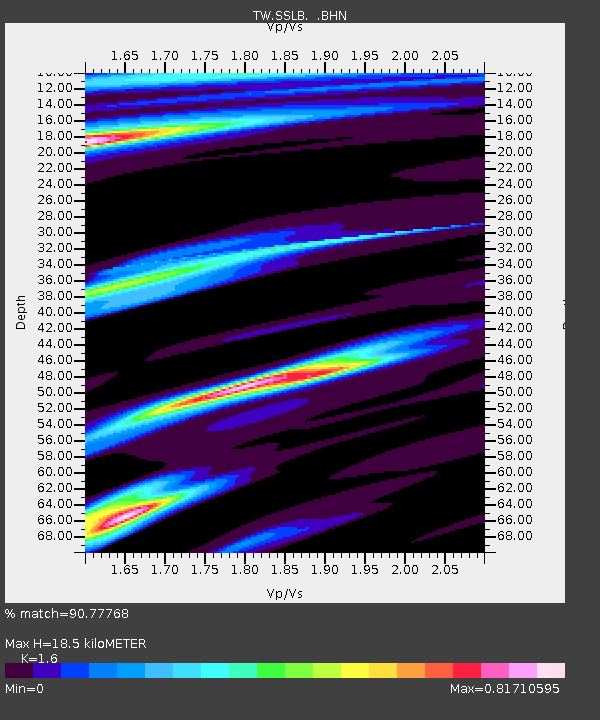
SSLB SUANG-LONG - Earthquake Result Viewer

Earthquake location: Southwest Of Sumatra, Indonesia
Earthquake latitude/longitude: -6.2/103.1
Earthquake time(UTC): 2005/05/10 (130) 01:09:05 GMT
Earthquake Depth: 17 km
Earthquake Magnitude: 5.9 MB, 6.4 MS, 6.2 MW, 6.2 MW
Earthquake Catalog/Contributor: WHDF/NEIC
Network: TW Broadband Array in Taiwan for Seismology
Station: SSLB SUANG-LONG
Lat/Lon: 23.79 N/120.95 E
Elevation: 450 m
Distance: 34.5 deg
Az: 29.632 deg
Baz: 212.453 deg
Ray Param: 0.07767775
Estimated Moho Depth: 18.5 km
Estimated Crust Vp/Vs: 1.60
Assumed Crust Vp: 6.461 km/s
Estimated Crust Vs: 4.038 km/s
Estimated Crust Poisson's Ratio: 0.18
Radial Match: 90.77768 %
Radial Bump: 400
Transverse Match: 82.74842 %
Transverse Bump: 400
SOD ConfigId: 2455
Insert Time: 2010-03-09 21:51:18.943 +0000
GWidth: 2.5
Max Bumps: 400
Tol: 0.001

Signal To Noise

ChannelStoNSTALTA
TW:SSLB: :BHN:20050510T01:15:21.757013Z3.13928537.7398795E-72.465491E-7
TW:SSLB: :BHE:20050510T01:15:21.757013Z3.52549159.397033E-72.6654536E-7
TW:SSLB: :BHZ:20050510T01:15:21.757013Z9.7140282.5752033E-62.651015E-7
Arrivals
Ps1.9 SECOND
PpPs6.8 SECOND
PsPs/PpSs8.7 SECOND