You are here: Home > Network List > XM99 - Rio Grande Seismic Transect Stations List
> Station NM27 NewMexico27 > Earthquake Result Viewer
NM27 NewMexico27 - Earthquake Result Viewer
| Earthquake location: |
Southeast Of Loyalty Islands |
| Earthquake latitude/longitude: |
-22.0/170.1 |
| Earthquake time(UTC): |
2001/02/28 (059) 13:05:31 GMT |
| Earthquake Depth: |
10 km |
| Earthquake Magnitude: |
5.8 MB, 6.1 MS, 6.2 MW |
| Earthquake Catalog/Contributor: |
WHDF/NEIC |
|
| Network: |
XM Rio Grande Seismic Transect |
| Station: |
NM27 NewMexico27 |
| Lat/Lon: |
34.39 N/106.52 W |
| Elevation: |
1870 m |
|
| Distance: |
96.9 deg |
| Az: |
55.847 deg |
| Baz: |
248.222 deg |
| Ray Param: |
0.040365636 |
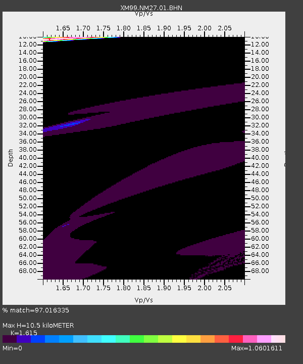
| Estimated Moho Depth: |
10.5 km |
| Estimated Crust Vp/Vs: |
1.62 |
| Assumed Crust Vp: |
6.502 km/s |
| Estimated Crust Vs: |
4.026 km/s |
| Estimated Crust Poisson's Ratio: |
0.19 |
|
| Radial Match: |
97.016335 % |
| Radial Bump: |
383 |
| Transverse Match: |
49.10869 % |
| Transverse Bump: |
400 |
| SOD ConfigId: |
3744 |
| Insert Time: |
2010-02-26 17:31:54.684 +0000 |
| GWidth: |
2.5 |
| Max Bumps: |
400 |
| Tol: |
0.001 |
|

Signal To Noise
| Channel | StoN | STA | LTA |
| XM:NM27:01:BHN:20010228T13:18:31.366013Z | 2.1019523 | 1.2326276E-6 | 5.8642036E-7 |
| XM:NM27:01:BHE:20010228T13:18:31.366013Z | 1.170731 | 3.7859727E-6 | 3.2338537E-6 |
| XM:NM27:01:BHZ:20010228T13:18:31.366013Z | 0.95798117 | 3.313645E-6 | 3.4589877E-6 |
| Arrivals |
| Ps | 1.0 SECOND |
| PpPs | 4.1 SECOND |
| PsPs/PpSs | 5.1 SECOND |


