You are here: Home > Network List > AK - Alaska Regional Network Stations List
> Station H23K Yukon River, AK, USA > Earthquake Result Viewer
H23K Yukon River, AK, USA - Earthquake Result Viewer
| Earthquake location: |
Hokkaido, Japan Region |
| Earthquake latitude/longitude: |
45.9/142.1 |
| Earthquake time(UTC): |
2022/07/02 (183) 01:59:45 GMT |
| Earthquake Depth: |
322 km |
| Earthquake Magnitude: |
5.8 mww |
| Earthquake Catalog/Contributor: |
NEIC PDE/us |
|
| Network: |
AK Alaska Regional Network |
| Station: |
H23K Yukon River, AK, USA |
| Lat/Lon: |
65.83 N/149.54 W |
| Elevation: |
617 m |
|
| Distance: |
40.7 deg |
| Az: |
35.948 deg |
| Baz: |
275.249 deg |
| Ray Param: |
0.07289416 |
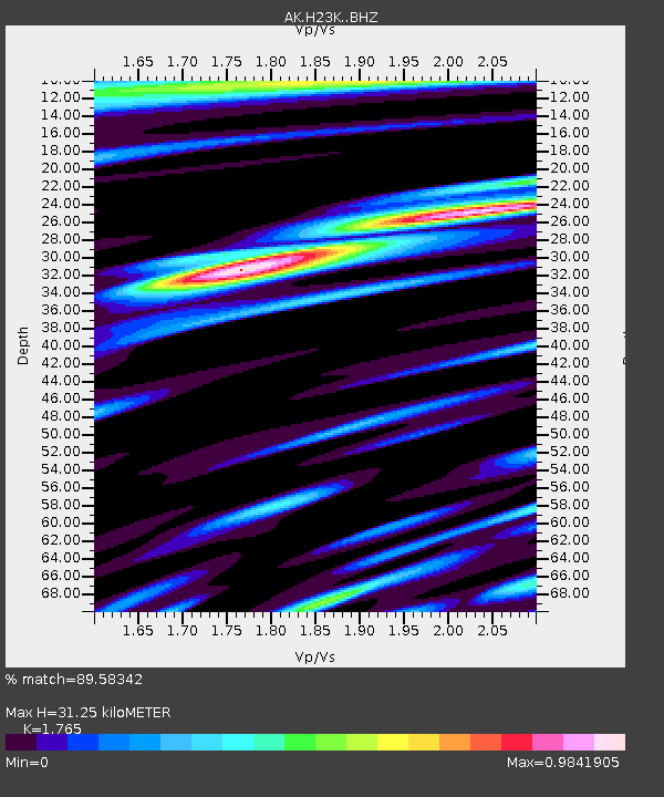
| Estimated Moho Depth: |
31.25 km |
| Estimated Crust Vp/Vs: |
1.76 |
| Assumed Crust Vp: |
6.566 km/s |
| Estimated Crust Vs: |
3.72 km/s |
| Estimated Crust Poisson's Ratio: |
0.26 |
|
| Radial Match: |
89.58342 % |
| Radial Bump: |
400 |
| Transverse Match: |
77.42652 % |
| Transverse Bump: |
400 |
| SOD ConfigId: |
28208852 |
| Insert Time: |
2022-07-16 02:05:19.514 +0000 |
| GWidth: |
2.5 |
| Max Bumps: |
400 |
| Tol: |
0.001 |
|

Signal To Noise
| Channel | StoN | STA | LTA |
| AK:H23K: :BHZ:20220702T02:06:25.440Z | 31.541573 | 2.247037E-6 | 7.1240486E-8 |
| AK:H23K: :BHN:20220702T02:06:25.440Z | 5.5518827 | 2.453345E-7 | 4.418942E-8 |
| AK:H23K: :BHE:20220702T02:06:25.440Z | 17.63454 | 1.0087477E-6 | 5.720295E-8 |
| Arrivals |
| Ps | 3.9 SECOND |
| PpPs | 12 SECOND |
| PsPs/PpSs | 16 SECOND |


